St. John's International Airport (YYT) → Cape Spear
St. John's Airport (YYT) to Cape Spear
The drive from every airport and ferry ↓
- Distance
- 23.5 km
- Drive time
- In your maps app ↗
Use another map app
Apple Maps · Google Maps · Organic Maps · OsmAnd (both work offline, no tracking) · Waze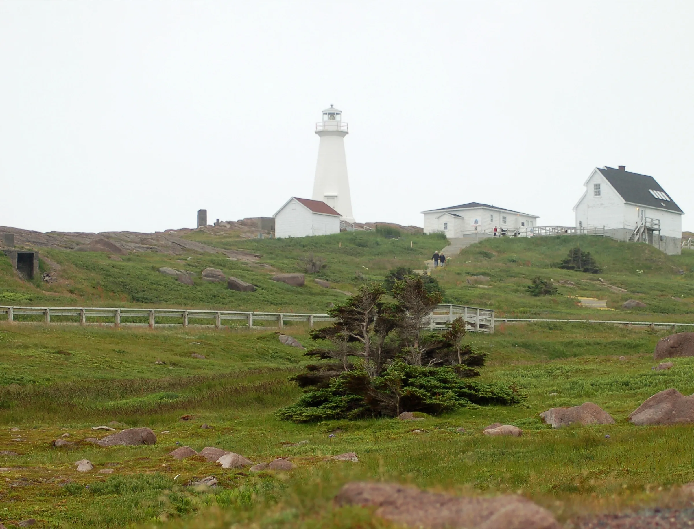

Faded lines are other drives from St. John's International into this area: Signal Hill (Cabot Tower) (9 km), Downtown St. John's (7.7 km), Portugal Cove ferry terminal (11 km), Witless Bay (46 km), Brigus (75 km), Harbour Grace (108 km). Each splits off where its line leaves this one.
Stop 1: Railway Coastal Museum
The drive passes it at 495 Water Street: St. John's old railway station, now the Railway Coastal Museum, about the Newfoundland Railway and the coastal boats.
Stopping here adds 0.3 km to the drive.
Directions →Show on map: Railway Coastal Museum ↑Other map apps
Apple · Google · Organic Maps · OsmAnd (both work offline, no tracking) · WazeStop 2: Blackhead One Room Church and School Museum
In Blackhead, on the road out to the cape, a small community museum by this name. A Facebook page is all we could find for it. Check there before you stop.
Stopping here adds 0.4 km to the drive.
Directions →Show on map: Blackhead One Room Church and School Museum ↑Other map apps
Apple · Google · Organic Maps · OsmAnd (both work offline, no tracking) · WazeStop 3: Cape Spear Lighthouse Museum
The end of the drive, and the lighthouse on the headland. Parks Canada's page for Cape Spear Lighthouse National Historic Site describes the oldest surviving lighthouse in Newfoundland and Labrador and the 19th century light-keeping families it interprets, and its activities page lists hiking, an interpretive trail, whale watching, bird watching and the remains of a Second World War coastal defence battery. Fees and exhibit hours are on Parks Canada's pages, linked below.
Stopping here adds 0.3 km to the drive.
Directions →Show on map: Cape Spear Lighthouse Museum ↑Other map apps
Apple · Google · Organic Maps · OsmAnd (both work offline, no tracking) · Waze
Scan with your phone to open this page there. Then tap Keep for offline before you lose signal.
⛽ Fuel and gravel, road by road ▾
- Route 40 →Whole road: 6 fuel stations mapped, longest gap 5.7 km. Unpaved mapped: none; 28% has no surface tag, so unknown.
- Route 11 →Whole road: 2 fuel stations mapped, longest gap 17 km. Unpaved mapped: none; 0% has no surface tag, so unknown.
Drive measured Sep 5, 2026, terminal to Cape Spear. Your maps app gives the time on the day. How we measure
Add to a trip →Staying here? Days out ↓Keep for offline ↓Download GPX (offline, Garmin)Airport info: St. John's International Airport →
23.5 km. From the terminal on Route 40, down through St. John’s to Water Street, then Route 11 out through Blackhead to the headland.
Read the safety page first. Parks Canada calls the terrain and coastline treacherous, names high winds and irregular tides, and asks visitors to stay on the designated trails.
Why people come. Canada’s most easterly point of land and the oldest surviving lighthouse in Newfoundland and Labrador, by Parks Canada’s account.
When you get to Cape Spear
- Where to eat near Cape Spear → — 1 place the open map records, alphabetically, with addresses and phone numbers.
Sunrise and sunset at Cape Spear, by month
| Month (the 15th) | Sunrise | Sunset |
|---|---|---|
| January | 7:43 am | 4:34 pm |
| February | 7:06 am | 5:22 pm |
| March | 7:14 am | 7:05 pm |
| April | 6:12 am | 7:48 pm |
| May | 5:23 am | 8:29 pm |
| June | 5:02 am | 8:59 pm |
| July | 5:18 am | 8:54 pm |
| August | 5:56 am | 8:14 pm |
| September | 6:36 am | 7:14 pm |
| October | 7:18 am | 6:13 pm |
| November | 7:05 am | 4:25 pm |
| December | 7:41 am | 4:09 pm |
Worked out for the 15th of each month at this spot, in local time. The weather line at the top has today's.
Places to eat on the way
52 near the start: where to eat in St. John's →
118 places to eat within 2 km of this drive, in the order you pass them.
The longest stretch with nothing mapped on it is 13.1 km — after Mary Brown's, to Cape Spear.
All 118, in the order you pass them — open the list
- Piattorestaurantkm 5.1 · 263 m off the road
- Wedgwood Cafe & Cateringrestaurantkm 5.1 · 429 m off the road
- Desi Mealrestaurantkm 5.3 · 399 m off the road
- Pizza Supremerestaurantkm 5.3 · 404 m off the road
- Sequerra's Restaurantrestaurantkm 5.3 · 395 m off the road
- Bitterspubkm 5.4 · 1461 m off the road
- Jumping Beancafékm 5.4 · 336 m off the road
- Big Bite Pitafast foodkm 5.7 · 947 m off the road
- MajesTeacafékm 5.7 · 941 m off the road
- Robin's Donutsfast foodkm 5.9 · 1957 m off the road
- Gracie Joe'srestaurantkm 6.3 · 957 m off the road
- Breezewaypubkm 6.5 · 1888 m off the road
- Ziggy Peelgoodfast foodkm 6.5 · 977 m off the road
- Tim Hortonscafékm 6.5 · 897 m off the road
- Donati'sfast foodkm 6.5 · 862 m off the road
- Pop's Dinerrestaurantkm 6.5 · 926 m off the road
- NJ's Kitchenrestaurantkm 6.5 · 884 m off the road
- Jumping Beancafékm 6.5 · 1811 m off the road
- Tim Hortonscafékm 6.5 · 1967 m off the road
- Mary Brown'sfast foodkm 6.5 · 1839 m off the road
- Booster Juicefast foodkm 6.5 · 1834 m off the road
- Manchu Wokfast foodkm 6.5 · 1828 m off the road
- Pizza Delightrestaurantkm 6.5 · 1819 m off the road
- Just Friesfast foodkm 6.5 · 1815 m off the road
- Smitty'srestaurantkm 6.5 · 910 m off the road
- Noodle Namirestaurantkm 6.5 · 889 m off the road
- Subwayfast foodkm 6.5 · 1074 m off the road
- Quintana'srestaurantkm 6.5 · 1036 m off the road
- Big Ben's Pubpubkm 6.5 · 1026 m off the road
- The Georgetown Pubpubkm 6.7 · 356 m off the road
- Beavertailsfast foodkm 6.8
- Georgestown Cafe and Bookshelfcafékm 6.8 · 335 m off the road
- The Parlourrestaurantkm 6.9 · 186 m off the road
- Hungry Heartcafékm 7
- Coffee Matterscafékm 7.1 · 500 m off the road
- Bannerman Brewing Co.pubkm 7.1 · 527 m off the road
- Pirestaurantkm 7.3 · 225 m off the road
- No.4 Restaurant & Barrestaurantkm 7.3 · 162 m off the road
- Peaceful Loftrestaurantkm 7.4
- Bamboo Gardenrestaurantkm 7.4
- Bagel Caferestaurantkm 7.4
- Sun Sushi & Bubbled Tearestaurantkm 7.4 · 198 m off the road
- Get Stuffedrestaurantkm 7.4 · 182 m off the road
- Fixed Coffee and Bakingcafékm 7.4 · 204 m off the road
- Smitty'srestaurantkm 7.4 · 380 m off the road
- Portobello's Restaurantrestaurantkm 7.4 · 438 m off the road
- International Flavoursrestaurantkm 7.4 · 839 m off the road
- Classic Cafe Eastcafékm 7.4 · 559 m off the road
- J Korean Restaurantrestaurantkm 7.4 · 174 m off the road
- Zachary's Restaurantrestaurantkm 7.4 · 566 m off the road
- Chatters Coffeecafékm 7.4 · 462 m off the road
- Fat Nanny'scafékm 7.4
- Shalimarrestaurantkm 7.4
- Ship Pubpubkm 7.4
- Battery Cafecafékm 7.4 · 807 m off the road
- India Gaterestaurantkm 7.4
- Saltwaterrestaurantkm 7.4
- Newfoundland Chocolate Cafecafékm 7.5 · 1387 m off the road
- Oliver'srestaurantkm 7.6
- Water St.Varietycafékm 7.6
- Smoke's Poutinefast foodkm 7.6
- Biancarestaurantkm 7.6
- The Fifth Ticketrestaurantkm 7.6
- 3 Sisters Vietnamese Subsfast foodkm 7.7
- Duke of Duckworthpubkm 7.7
- Cojones Tacos & Tequilarestaurantkm 7.7
- Sushi Islandrestaurantkm 7.9
- Ziggy Peelgoods French Friesfast foodkm 7.9
- Jumping Bean Coffeecafékm 7.9 · 463 m off the road
- Yellowbelly Brewerypubkm 8.1
- The Kegrestaurantkm 8.1
- Afghan Restaurantrestaurantkm 8.1
- Piatto Restaurantrestaurantkm 8.1 · 151 m off the road
- The Republicpubkm 8.1 · 155 m off the road
- The Sprout Restaurantrestaurantkm 8.1 · 156 m off the road
- Jack Astor'srestaurantkm 8.1
- O'Reilly'spubkm 8.1
- Trapper John's Museum & Pubpubkm 8.1
- Rob Roy Pubpubkm 8.1
- Green Sleeves Pub & Restaurantpubkm 8.1
- Formosa Tea Houserestaurantkm 8.1 · 527 m off the road
- Celtic Hearthrestaurantkm 8.1
- Bridie Molloy’spubkm 8.1
- Merchant Tavernrestaurantkm 8.1
- Chinchedrestaurantkm 8.1 · 175 m off the road
- Carribean Cornerrestaurantkm 8.1
- LIVrestaurantkm 8.1
- Frugal Steinsrestaurantkm 8.1
- Saltwaterrestaurantkm 8.1
- Black Cat Pizzeriarestaurantkm 8.1 · 526 m off the road
- Tim Hortonscafékm 8.1 · 529 m off the road
- Ches' Fish & Chipsfast foodkm 8.1 · 580 m off the road
- Fat Bastard Burritofast foodkm 8.2
- Downtown Pizza fast foodkm 8.2
- Kelly's Pubpubkm 8.2
- Shamrock City Pubpubkm 8.2
- Christian'spubkm 8.2
- Adelaide Oyster Houserestaurantkm 8.2
- Gahan Housepubkm 8.2
- Subwayfast foodkm 8.2
- Chinched Bistrorestaurantkm 8.5
- Humphreys Restaurant and Pubrestaurantkm 8.5
- Fiddlers Pubpubkm 8.5
- Fabulous Foodsrestaurantkm 8.5 · 1033 m off the road
- Leo's Fish and Chipsfast foodkm 8.5 · 622 m off the road
- The Station Loungepubkm 8.9
- RJ Pinoy Yumrestaurantkm 9.5 · 1446 m off the road
- No Name Pizzafast foodkm 9.5 · 1402 m off the road
- Tim Hortonscafékm 9.6
- Subwayfast foodkm 9.8 · 1311 m off the road
- Ziggy Peelgoodsfast foodkm 9.8 · 1349 m off the road
- Mr. Subfast foodkm 9.8 · 1408 m off the road
- The Cove Climbing Cafécafékm 9.8 · 604 m off the road
- Tim Hortonscafékm 9.8 · 1374 m off the road
- Burger Kingfast foodkm 9.8 · 1410 m off the road
- KFCfast foodkm 9.8 · 1452 m off the road
- The Big R Restaurantrestaurantkm 10.3 · 1430 m off the road
- Mary Brown'sfast foodkm 10.3 · 1732 m off the road
Not ranked or complete, and nobody pays to be here. No opening hours: phone ahead. Open map data, swept 2026-09-12. How we measure · Add a missing place
New place to eat, or one that's missing? This list comes from OpenStreetMap, so nobody can pay to be on it. Add it to the map yourself (about twenty minutes on a phone), or email us the details and we'll put it on the map.
Icebergs recorded here, not at 48°N
The odds on this site come from the count of bergs crossing 48°N, out in the shipping lanes. These are the ones the same patrol recorded near Cape Spear itself, across 19 seasons (2002–2021), counted as distinct icebergs rather than sightings.
At least one was recorded within 50 km in 16 of those 19 seasons. The middling season brought 62; the heaviest, 131 in 2019. Widen to 100 km and the middling season is 157.
This is not what you would see from the shore. It is where a patrol whose job is shipping recorded ice, so where they looked shapes it, and a berg 50 km out to sea is not a berg in the harbour. The record runs to 2021 and stops there. From the International Ice Patrol Iceberg Sightings Database (NSIDC G00807), built 2026-10-07.
What has been recorded near here
Wildlife people have reported within 10 km of Cape Spear, and the months they saw it. Tap a name for everywhere else on our drives it turns up.
- Northern gannetseabirdMorus bassanusReports cluster in July, June, August2,698 reports on record
- Atlantic puffinseabirdFratercula arcticaReports cluster in July, August, June1,004 reports on record
- Humpback whalewhaleMegaptera novaeangliaeReports cluster in July, June, August206 reports on record
- Minke whalewhaleBalaenoptera acutorostrataReports cluster in June, July, May24 reports on record
Reports, not counts: busy harbours report more. No sighting is promised, and the list covers only the species we look up. Source: GBIF, the international record of wildlife sightings, checked 2026-10-07.
Short drives from Cape Spear
Other map apps
Apple · Google · Organic Maps · OsmAnd (both work offline, no tracking) · WazeOr any of these: nearest first, measured by road from Cape Spear.
- Deadmans Bay Pathtrail · 10.5 km point to point, one way · moderate to difficult3.7 kmDirections →
Other map apps
Apple · Google · Organic Maps · OsmAnd (both work offline, no tracking) · Waze - Motion Pathtrail · 13.8 km point to point, one way · moderate to difficult14 kmDirections →
Other map apps
Apple · Google · Organic Maps · OsmAnd (both work offline, no tracking) · Waze - St. John'stown16 kmDirections →
Other map apps
Apple · Google · Organic Maps · OsmAnd (both work offline, no tracking) · Waze - Trans-Canada Highway Zero Kmstop16 km
OpenStreetMap records a highway milestone here reading distance zero, named for the Trans-Canada Highway.
Directions →Other map apps
Apple · Google · Organic Maps · OsmAnd (both work offline, no tracking) · Waze A few hundred metres along Military Road: Parks Canada's register describes a massive stone cathedral built in the mid 19th century in the Lombard Romanesque Revival style, a national historic site since 1983.
Directions →Other map apps
Apple · Google · Organic Maps · OsmAnd (both work offline, no tracking) · Waze- Colonial Buildingstop17 km
On Military Road as the drive comes down into town.
Directions →Other map apps
Apple · Google · Organic Maps · OsmAnd (both work offline, no tracking) · Waze - Fort Amherst Lighthouselighthouse17 kmDirections →
Other map apps
Apple · Google · Organic Maps · OsmAnd (both work offline, no tracking) · Waze - The Batterystop18 km
On the harbour side of Signal Hill Road.
Directions →Other map apps
Apple · Google · Organic Maps · OsmAnd (both work offline, no tracking) · Waze
More, up to 39 km (10)
- Signal Hill Visitor Centrestop18 km
Halfway up Signal Hill Road.
Directions →Other map apps
Apple · Google · Organic Maps · OsmAnd (both work offline, no tracking) · Waze - Quidi Vidistop18 km
A small village on its own harbour, north of Signal Hill.
Directions →Other map apps
Apple · Google · Organic Maps · OsmAnd (both work offline, no tracking) · Waze - North Head Trailtrail · 1.6 km point to point, one way · easy18 kmDirections →
Other map apps
Apple · Google · Organic Maps · OsmAnd (both work offline, no tracking) · Waze On screen: the marine research lab where Calvin tries to sell the iceberg fragment he caught, in the first episode.
Directions →Other map apps
Apple · Google · Organic Maps · OsmAnd (both work offline, no tracking) · Waze- Father Troy's Pathtrail · 8.9 km point to point, one way · easy30 kmDirections →
Other map apps
Apple · Google · Organic Maps · OsmAnd (both work offline, no tracking) · Waze - Portugal Cove ferry terminaltown32 kmDirections →
Other map apps
Apple · Google · Organic Maps · OsmAnd (both work offline, no tracking) · Waze - Piccos Ridge Pathtrail · 14.5 km point to point, one way · strenuous33 kmDirections →
Other map apps
Apple · Google · Organic Maps · OsmAnd (both work offline, no tracking) · Waze - Manuel's River Interpretation Centerstop35 km
A fossil bed and walking trail on Manuels River, with guided walks back to when trilobites ruled the seas.
Directions →Other map apps
Apple · Google · Organic Maps · OsmAnd (both work offline, no tracking) · Waze - Bay Bulls harbourstop36 km
On screen: where Wade and Jerry head out at night from the marine base to harvest an iceberg.
Directions →Other map apps
Apple · Google · Organic Maps · OsmAnd (both work offline, no tracking) · Waze - Spout Pathtrail · 16.2 km point to point, one way · strenuous39 kmDirections →
Other map apps
Apple · Google · Organic Maps · OsmAnd (both work offline, no tracking) · Waze
Distances by road, measured on OpenStreetMap October 16, 2026, from where this route ends. Your maps app gives the time on the day. How we measure
Doing it electric
- Fast chargers on this drive
- none
- Longest stretch without one
- 23 km
- St. John's → Cape Spear, of 23 km driven
- Nearest fast charger to Cape Spear
- 25.7 km
- by road, at St. John’s
No fast charger at Cape Spear. From St. John's it is 23 km there and the same back: plan on about 46 km on one charge, more in cold weather or with the heat on. Or charge at St. John’s, 25.7 km from Cape Spear by road, off this drive's own road.
NL Hydro fast chargers within 3 km of the drive. Check the app for one that's working. Exported 2026-10-22. How we measure
Paved or not, per the map
- Mapped as unpaved
- none
- Not proof it is all paved: 14% has no surface tag.
- Mapped as paved
- 86%
- 17.2 km of 23.5 km driven
- No surface tag on the map
- 14%
- 2.8 km: surface not recorded
In a rental car: Hertz Canada’s terms say “use off paved roads or on roads which are not regularly maintained” voids the damage waiver. Check your own agreement. Hertz’s terms ↗. Source for these figures: OSRM driving profile, stored route query, with node annotations; OpenStreetMap surface tags via Overpass, checked 2026-09-13. Today's road conditions: 511.
Before you go
These change, so we link to the people who keep them up to date.
MooseYear round, worst between dusk and dawn
The province states the likelihood of injury in a moose collision is about twice as high between dusk and dawn as in daytime. Much of this short drive is city street, but the last stretch runs out to an open headland. Take care there near dusk.
gov.nl.ca →Road conditionsYear round, matters most November–April
A short drive can still be hard in winter, and the far end is open coast. Check the province's road conditions before you go.
511nl.ca →Cliffs and coastline at the capeWhenever you are on the headland
Parks Canada's safety page says the terrain and coastline at Cape Spear are treacherous, and high winds, irregular tides and ocean action make a dangerous combination when visitors leave the designated hiking trails. It tells visitors to stay on those trails and off the rocks near the water's edge, and notes that cell coverage can be limited. Read it before you walk out past the lighthouse.
parks.canada.ca →Lighthouse exhibitThe exhibit keeps a visitor season; the grounds do not follow it
Parks Canada sets the lighthouse's season and fees, and both change. The grounds are open year-round, it says, but the exhibit is not. Check Parks Canada before you plan around the exhibit.
parks.canada.ca →
Renting a car? Book the car when you book the flight.
Summer rentals sell out, says NL Tourism, and in June 2026 BNN Bloomberg reported St. John's airport agencies booked for nearly all of summer.
Both checked October 7, 2026.
Rental counters at St. John's, with numbers →Arriving without a car
Not renting? Here's who St. John's International Airport Authority lists at the terminal.
Rideshare: it depends who you ask.
The Airport Authority's own ground-transportation pages name City Wide Taxi as “the exclusive provider of ground transportation services for the public” and do not mention rideshare anywhere. Uber publishes pickup instructions for YYT, and the Airport's own account welcomed Uber in 2024. Both are true. The Authority's pages govern the kerb, so check them on the day.
Taxi
City Wide Taxi, which the Airport Authority names as the exclusive provider for the public. Cabs queue outside the Arrivals area and a dispatcher is there to help. The Authority publishes preset fares to named hotels and a meter-plus-surcharge rate everywhere else.
Public transit
Metrobus route 14 runs between the airport and the St. John's metro region, including Memorial University. There are two stops at the airport: one near the arrivals area, and one on World Parkway by the Holiday Inn Express. The Authority says Metrobus has committed to a wheelchair-accessible service on this route and can take large, non-folding mobility aids. Schedule and fares are Metrobus's.
Source: St. John's International Airport Authority,2026-09-15. Check there for fares and times.
The drive back
Measured the other way, Cape Spear back to St. John's is the same distance: 24 km.
Plan back from your check-in time. Give the planner your flight time and it tells you when to set off.
How early to arrive depends on the carrier and the season: check St. John's International Airport →
Return measured 2026-09-29, the same way as the drive out. How we measure
Questions
How far is Cape Spear from St. John's Airport?+
About 23.5 km, measured from the terminal to the cape. The numbered roads are Route 40, which OpenStreetMap carries on Portugal Cove Road at the airport end, and Route 11, which it carries on Blackhead Road out to the headland; the stretch between them is city street.
Should I fly into St. John's, Gander or Deer Lake for Cape Spear?+
St. John's, by a wide margin. From the terminal to the cape it is 23.5 km from St. John's, 346 km from Gander and 649 km from Deer Lake.
Is Cape Spear really the easternmost point in North America?+
Parks Canada says Cape Spear is Canada's most easterly point of land, and that is the claim this page makes. The North America version turns up widely, including in OpenStreetMap's description of the cape, which calls it the most easterly point in America. Parks Canada does not say that, so neither do we.
What is there to do at Cape Spear besides the drive?+
Parks Canada's activities page for the site lists hiking, an interpretive trail, a lookout, the museum, whale watching, bird watching, photography and picnicking, and describes exploring the remains of a Second World War coastal defence battery on the headland. Cape Spear is also one of the shore whale-viewing spots the province names.
Will the lighthouse be open when I get there?+
It depends on the day. The exhibit keeps a visitor season and charges admission; the grounds, Parks Canada says, are open year-round. Check Parks Canada's pages, linked in the seasonal notes above.
No recorded track yet.Drove it? Send yours →
Put this map on your site
Run a place to stay, a tour or a town page on this drive? Add this map to your site. It shows your guests the drive and its distance. It is free, needs no account, and we keep the figures current.
<iframe src="https://fromtheairport.xyz/embed/yyt-cape-spear"
  width="100%" height="420" style="border:0" loading="lazy"
title="Driving route: St. John's International Airport (YYT) to Cape Spear"></iframe>?lat=&lon=&label= to the URL to pin your own property on the map.Every distance and coordinate on this page was checked against its source on September 6, 2026. Origin: OpenStreetMap way/279110348 — aeroway=terminal, St. John's International Airport. Destination: OpenStreetMap node/470734348 — Cape Spear.