St. John's International Airport (YYT) → Cape St. Mary's Ecological Reserve
St. John's Airport (YYT) to Cape St. Mary's
The drive from every airport and ferry ↓
- Electric: plan 318 km on a charge. Chargers ↓
- Distance
- 176.5 km
- Drive time
- In your maps app ↗
Use another map app
Apple Maps · Google Maps · Organic Maps · OsmAnd (both work offline, no tracking) · Waze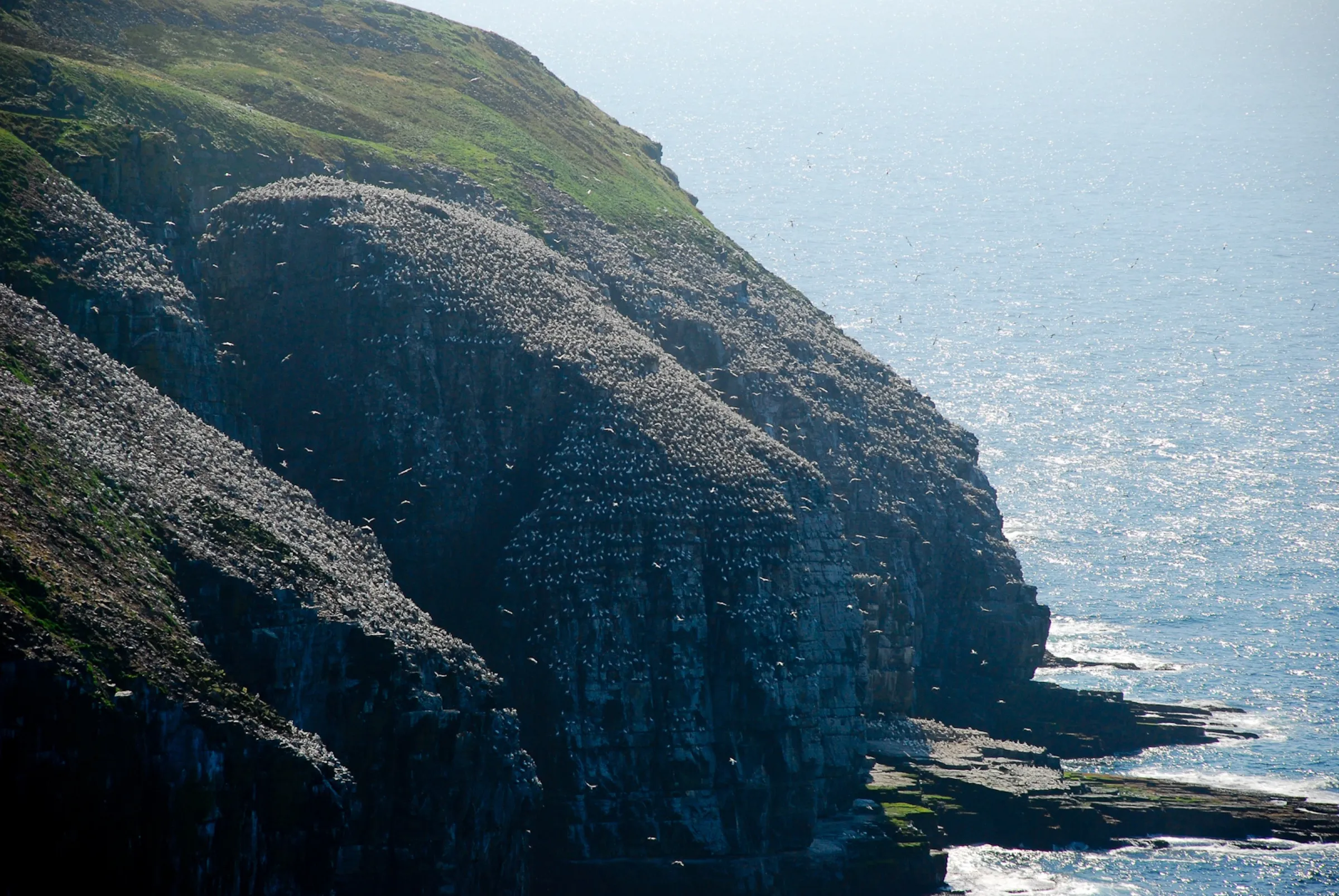

Faded lines are other drives from St. John's International into this area: Placentia (132 km). Each splits off where its line leaves this one.
Stop 1: Father Duffy's Well
A roadside stop on the Salmonier Line. The Dictionary of Canadian Biography calls it the resting place of James W. Duffy on his many journeys between St. Mary's and St. John's. An Irish priest brought over by Bishop Fleming, Duffy built a church at St. Mary's in the 1830s on ground the merchant company's agent objected to. After a crowd burned the fish flake blocking the way, he was charged, and the case dragged through the St. John's courts until the crown gave up.
Stopping here adds 0.1 km to the drive.
Directions →Show on map: Father Duffy's Well ↑Other map apps
Apple · Google · Organic Maps · OsmAnd (both work offline, no tracking) · WazeStop 2: Salmonier Nature Park
Run by the province's wildlife division, further along the Salmonier Line. By its own account it opened in 1978 as an environmental education centre and grew into a tourist destination. The animals live in large natural enclosures along a boardwalk trail, among them the Newfoundland marten, for which staff built a captive-breeding enclosure while it was designated endangered. The province coordinates its wildlife rehabilitation from here, and most of the animals arrived injured and unreleasable.
Stopping here adds 0.1 km to the drive.
Directions →Show on map: Salmonier Nature Park ↑Other map apps
Apple · Google · Organic Maps · OsmAnd (both work offline, no tracking) · Waze
Scan with your phone to open this page there. Then tap Keep for offline before you lose signal.
⛽ Fuel and gravel, road by road ▾
- Route 40 →Whole road: 6 fuel stations mapped, longest gap 5.7 km. Unpaved mapped: none; 28% has no surface tag, so unknown.
- Route 1 →Whole road: 54 fuel stations mapped, longest gap 119 km. Unpaved mapped: none; 68% has no surface tag, so unknown.
- Route 90 →Whole road: 4 fuel stations mapped, longest gap 34 km. Unpaved mapped: none; 55% has no surface tag, so unknown.
- Route 91 →Whole road: 2 fuel stations mapped, longest gap 49 km. Unpaved mapped: 24 km; 0% has no surface tag, so unknown.
- Route 92 →Whole road: 0 fuel stations mapped, longest gap 52 km. Unpaved mapped: none; 0% has no surface tag, so unknown.
- Route 100 →Whole road: 3 fuel stations mapped, longest gap 63 km. Unpaved mapped: none; 0% has no surface tag, so unknown.
Drive measured Sep 5, 2026, St. John's International Airport (YYT) to Cape St. Mary's Ecological Reserve. Your maps app gives the time on the day. How we measure
Add to a trip →Keep for offline ↓Download GPX (offline, Garmin)Airport info: St. John's International Airport →
176.5 km. St. John’s airport to Cape St. Mary’s Ecological Reserve: the Trans-Canada, the Salmonier Line (Route 90) south across the Avalon, then Route 100 along the Cape Shore. The reserve’s access road turns off east of St. Bride’s.
Why people come. A cliff-top viewing area, reached on foot across the barrens, faces a sandstone sea stack where Northern gannets nest, close enough to watch from land.
The walk, in the reserve’s words. 1.4 km each way to the viewing area, about 20 to 30 minutes, on an unpaved footpath that can be muddy or slippery; sturdy footwear, and care near the cliff edge. Bird Rock is across a narrow chasm from where you stand. Fog is common, most of all April to June; on a closed-in day the reserve points you to its interpretive centre. (Cape St. Mary’s Ecological Reserve)
Puffins too? This drive is for the gannets. The province places North America’s largest Atlantic puffin colony in the Witless Bay Ecological Reserve, seen from licensed tour boats: the drive to Witless Bay.
Sunrise and sunset at Cape St. Mary's Ecological Reserve, by month
| Month (the 15th) | Sunrise | Sunset |
|---|---|---|
| January | 7:47 am | 4:43 pm |
| February | 7:11 am | 5:30 pm |
| March | 7:20 am | 7:11 pm |
| April | 6:20 am | 7:53 pm |
| May | 5:32 am | 8:33 pm |
| June | 5:11 am | 9:02 pm |
| July | 5:27 am | 8:58 pm |
| August | 6:03 am | 8:19 pm |
| September | 6:43 am | 7:20 pm |
| October | 7:23 am | 6:20 pm |
| November | 7:09 am | 4:33 pm |
| December | 7:45 am | 4:19 pm |
Worked out for the 15th of each month at this spot, in local time. The weather line at the top has today's.
Places to eat on the way
57 near the start: where to eat in St. John's →
57 places to eat within 2 km of this drive, in the order you pass them.
The longest stretch with nothing mapped on it is 158.7 km — after Costco Food Court, to Cape St. Mary's Ecological Reserve.
All 57, in the order you pass them — open the list
- Breezewaypubkm 5 · 1246 m off the road
- Jumping Beancafékm 5 · 1435 m off the road
- Mary Brown'sfast foodkm 5 · 1275 m off the road
- Booster Juicefast foodkm 5 · 1282 m off the road
- Manchu Wokfast foodkm 5 · 1290 m off the road
- Pizza Delightrestaurantkm 5 · 1304 m off the road
- Just Friesfast foodkm 5 · 1309 m off the road
- Tim Hortonscafékm 5.1 · 1539 m off the road
- The Pantry (Autism Society Foundation Room)restaurantkm 5.2 · 764 m off the road
- McDonald'sfast foodkm 5.3 · 1855 m off the road
- The Guv'nor Pubpubkm 5.3 · 1851 m off the road
- Domino'sfast foodkm 5.4 · 1922 m off the road
- The Bigs Ultimate Sports Grillrestaurantkm 5.5 · 1892 m off the road
- Old Town Pizzafast foodkm 5.6 · 1911 m off the road
- Mary Brown'sfast foodkm 5.6 · 1920 m off the road
- Subwayfast foodkm 6.1 · 1819 m off the road
- Mary Brown'sfast foodkm 6.1 · 1784 m off the road
- A&Wfast foodkm 6.1 · 1803 m off the road
- Dairy Queenfast foodkm 6.1 · 1831 m off the road
- Tim Hortonscafékm 6.1 · 1797 m off the road
- Mr. Souvlakifast foodkm 6.1 · 1790 m off the road
- Peters Pizzarestaurantkm 6.1 · 1740 m off the road
- Burger Kingfast foodkm 6.1 · 1998 m off the road
- Tim Hortonscafékm 6.9 · 1231 m off the road
- Red Pepper Restaurantrestaurantkm 6.9 · 1894 m off the road
- Cora'srestaurantkm 6.9 · 1961 m off the road
- Scamper's Snack Barrestaurantkm 6.9 · 1806 m off the road
- Tim Hortonscafékm 6.9 · 1236 m off the road
- Montana'srestaurantkm 6.9 · 1975 m off the road
- McDonald'sfast foodkm 8.2 · 1855 m off the road
- Dairy Queenfast foodkm 14.7 · 254 m off the road
- Kozy Kitchenrestaurantkm 14.7
- Mary Brown'sfast foodkm 14.7 · 206 m off the road
- Mr. G's Loungepubkm 14.7 · 338 m off the road
- Ocean Sushirestaurantkm 14.7 · 331 m off the road
- Peter's Pizzafast foodkm 14.7 · 345 m off the road
- Tim Hortonscafékm 14.7 · 285 m off the road
- Tiny's Bar and Grillrestaurantkm 14.7 · 329 m off the road
- McDonald'sfast foodkm 14.8 · 536 m off the road
- Ye's Wokrestaurantkm 14.9 · 654 m off the road
- A&Wfast foodkm 14.9 · 727 m off the road
- Coffee Matters Paradisecafékm 15 · 726 m off the road
- Domino'sfast foodkm 15.2 · 1097 m off the road
- Subwayfast foodkm 15.2 · 1173 m off the road
- Cojonesrestaurantkm 15.2 · 1069 m off the road
- Pizza Housefast foodkm 15.3 · 1855 m off the road
- Subwayfast foodkm 15.3 · 535 m off the road
- Robin's Donutsfast foodkm 15.7 · 450 m off the road
- Donovan's Irvingrestaurantkm 15.9 · 622 m off the road
- A&Wfast foodkm 16.5 · 1700 m off the road
- A&Wfast foodkm 16.5 · 1700 m off the road
- Canteenrestaurantkm 16.9 · 1756 m off the road
- Starbuckscafékm 17.1 · 1642 m off the road
- Pizza Hutrestaurantkm 17.1 · 1773 m off the road
- Tim Hortonscafékm 17.1 · 1941 m off the road
- A&Wfast foodkm 17.1 · 1885 m off the road
- Costco Food Courtfast foodkm 17.2 · 1456 m off the road
Not ranked or complete, and nobody pays to be here. No opening hours: phone ahead. Open map data, swept 2026-09-12. How we measure · Add a missing place
New place to eat, or one that's missing? This list comes from OpenStreetMap, so nobody can pay to be on it. Add it to the map yourself (about twenty minutes on a phone), or email us the details and we'll put it on the map.
What has been recorded near here
Wildlife people have reported within 10 km of Cape St. Mary's Ecological Reserve, and the months they saw it. Tap a name for everywhere else on our drives it turns up.
- Northern gannetseabirdMorus bassanusReports cluster in July, June, August2,091 reports on record
- Atlantic puffinseabirdFratercula arcticaReports cluster in June, July, August126 reports on record
- Humpback whalewhaleMegaptera novaeangliaeReports cluster in July, June, August63 reports on record
Reports, not counts: busy harbours report more. No sighting is promised, and the list covers only the species we look up. Source: GBIF, the international record of wildlife sightings, checked 2026-10-07.
Doing it electric
- Fast chargers on this drive
- Paradise km 16, St. John’s km 17
- Longest stretch without one
- 159 km
- St. John’s → Cape St. Mary's Ecological Reserve, of 176 km driven
- Nearest fast charger to Cape St. Mary's Ecological Reserve
- 111.9 km
- by road, at Whitbourne
No fast charger at Cape St. Mary's Ecological Reserve. From St. John’s it is 159 km there and the same back: plan on about 318 km on one charge, more in cold weather or with the heat on. Or charge at Whitbourne, 111.9 km from Cape St. Mary's Ecological Reserve by road, off this drive's own road.
Coming in 2026 (NL Hydro, 2026-10-22): St. John’s (km 17). Not counted until it opens.
NL Hydro fast chargers within 3 km of the drive. Check the app for one that's working. Exported 2026-10-22. How we measure
Paved or not, per the map
- Mapped as unpaved
- none
- Not proof it is all paved: 18% has no surface tag.
- Mapped as paved
- 82%
- 133.9 km of 176.5 km driven
- No surface tag on the map
- 18%
- 30.3 km: surface not recorded
In a rental car: Hertz Canada’s terms say “use off paved roads or on roads which are not regularly maintained” voids the damage waiver. Check your own agreement. Hertz’s terms ↗. Source for these figures: OSRM driving profile, stored route query, with node annotations; OpenStreetMap surface tags via Overpass, checked 2026-09-13. Today's road conditions: 511.
Before you go
These change, so we link to the people who keep them up to date.
MooseYear round, worst between dusk and dawn
The province states the likelihood of injury in a moose collision is about twice as high between dusk and dawn as in daytime. Most of this drive is unlit rural two-lane highway on the Salmonier Line and the Cape Shore. Plan around dusk and dawn if you can, especially driving back after an evening at the reserve.
gov.nl.ca →Road conditionsYear round, matters most November–April
The first stretch is St. John's streets and the Trans-Canada. Check the exposed Cape Shore run to the reserve before you leave, especially outside summer.
511nl.ca →The reserveTypically the warmer months; the reserve sets the dates
Cape St. Mary's is a provincial ecological reserve with a staffed interpretive centre. Its season is on its own page. The reserve asks visitors to check weather and trail conditions there before setting out, and describes the cape as often foggy, windy and wet.
gov.nl.ca →
Renting a car? Book the car when you book the flight.
Summer rentals sell out, says NL Tourism, and in June 2026 BNN Bloomberg reported St. John's airport agencies booked for nearly all of summer.
Both checked October 7, 2026.
Rental counters at St. John's, with numbers →Arriving without a car
Not renting? Here's who St. John's International Airport Authority lists at the terminal.
Rideshare: it depends who you ask.
The Airport Authority's own ground-transportation pages name City Wide Taxi as “the exclusive provider of ground transportation services for the public” and do not mention rideshare anywhere. Uber publishes pickup instructions for YYT, and the Airport's own account welcomed Uber in 2024. Both are true. The Authority's pages govern the kerb, so check them on the day.
Taxi
City Wide Taxi, which the Airport Authority names as the exclusive provider for the public. Cabs queue outside the Arrivals area and a dispatcher is there to help. The Authority publishes preset fares to named hotels and a meter-plus-surcharge rate everywhere else.
Public transit
Metrobus route 14 runs between the airport and the St. John's metro region, including Memorial University. There are two stops at the airport: one near the arrivals area, and one on World Parkway by the Holiday Inn Express. The Authority says Metrobus has committed to a wheelchair-accessible service on this route and can take large, non-folding mobility aids. Schedule and fares are Metrobus's.
Source: St. John's International Airport Authority,2026-09-15. Check there for fares and times.
The drive back
Measured the other way, Cape St. Mary's Ecological Reserve back to St. John's is the same distance: 178 km.
Plan back from your check-in time. Give the planner your flight time and it tells you when to set off.
How early to arrive depends on the carrier and the season: check St. John's International Airport →
Return measured 2026-09-29, the same way as the drive out. How we measure
Questions
How far is Cape St. Mary's Ecological Reserve from St. John's airport?+
About 176 km, airport to the reserve. You take Route 40 out of the airport to the Trans-Canada (Route 1), then Routes 90, 91, 92 and 100 (the Salmonier Line across the Avalon, then the Cape Shore) to the reserve's access road.
Should I fly into St. John's, Gander or Deer Lake for Cape St. Mary's Ecological Reserve?+
St. John's, by a wide margin. The drive from St. John's airport is 177 km. From Gander it is 354 km, and from Deer Lake 657 km, a cross-island drive before the Cape Shore even starts. Fly into St. John's unless Cape St. Mary's ends a longer west-to-east trip.
Is there anything worth stopping for on the way?+
Two, both close to the line; the detour is printed beside each above. Father Duffy's Well is a historic roadside well on the Salmonier Line, tied by the Dictionary of Canadian Biography to a priest's journeys to court in St. John's in the 1830s. A little further, Salmonier Nature Park is the provincial wildlife park, with native animals in large natural enclosures along a boardwalk trail.
What is there to see at Cape St. Mary's itself?+
In the province's own words, one of the most spectacular and easily viewed nesting seabird colonies in the world. A footpath crosses coastal barrens to a cliff-top viewing area facing Bird Rock, a sandstone sea stack across a narrow chasm, where Northern gannets nest. Nesting, courtship and flying displays can all be watched from land. The reserve's page also lists whale watching among what the cape is for, and says whales are often seen offshore in summer.
When should I go, and is the drive different in winter?+
The reserve publishes its season and hours on its own page, linked above. The drive is highway all the way to the reserve's access road, with one exposed coastal stretch at the end. Check the road-conditions link above before a winter trip, and the reserve's page for weather at the cape.
How far is the walk to the birds, and how close do you get?+
The reserve says 1.4 km each way on a natural footpath across coastal barrens, about 20 to 30 minutes, unpaved and possibly muddy, wet or slippery. The viewing area faces Bird Rock, a 100-metre sandstone sea stack across a narrow chasm, and the gannets can be watched at close range. The trail and viewing area are not wheelchair accessible; the interpretive centre, parking and washrooms are. Fog is common, most of all April to June; on a closed-in day the reserve suggests the centre's exhibits.
No recorded track yet.Drove it? Send yours →
Put this map on your site
Run a place to stay, a tour or a town page on this drive? Add this map to your site. It shows your guests the drive and its distance. It is free, needs no account, and we keep the figures current.
<iframe src="https://fromtheairport.xyz/embed/yyt-cape-st-marys"
  width="100%" height="420" style="border:0" loading="lazy"
title="Driving route: St. John's International Airport (YYT) to Cape St. Mary's Ecological Reserve"></iframe>?lat=&lon=&label= to the URL to pin your own property on the map.Every distance and coordinate on this page was checked against its source on September 5, 2026. Origin: OpenStreetMap way/279110348 — St. John's International Airport. Destination: OpenStreetMap way/125454481 — Cape St. Mary's Ecological Reserve.