Argentia ferry terminal → Cape St. Mary's Ecological Reserve
Argentia ferry terminal to Cape St. Mary's Ecological Reserve
The drive from every airport and ferry ↓
- Distance
- 71.2 km
- Drive time
- In your maps app ↗
- Roads
- 100
Use another map app
Apple Maps · Google Maps · Organic Maps · OsmAnd (both work offline, no tracking) · Waze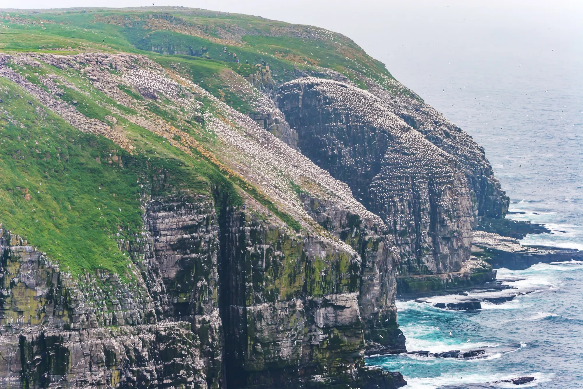

You arrive by ferry — North Sydney, Nova Scotia to Argentia
Marine Atlantic gives this crossing as about 16.5 hours over 518 km of water, mid-June to late September, up to three times a week — against seven hours year-round and daily into Port aux Basques. People choose it for where it lands them. Check Marine Atlantic for sailings and fares.
Operated by Marine Atlantic. The drive below starts where the boat lands.
Crossings & current schedule →Faded lines are other drives from Argentia ferry terminal into this area: Placentia (7.4 km). Each splits off where its line leaves this one.
Stop 1: Castle Hill National Historic SiteDetour
A Parks Canada site on the hill above Placentia, early in the drive. Parks Canada's own page describes the remnants of a stone fort, and invites visitors to imagine "cannons and muskets blazing as British and French forces battled on the shores of Newfoundland, vying for control of a lucrative fishery" in the 18th century, a chapter it says "determined the fate of a continent". Check Parks Canada for what is open and when.
Stopping here adds 1.8 km to the drive.
Directions →Show on map: Castle Hill National Historic Site ↑Other map apps
Apple · Google · Organic Maps · OsmAnd (both work offline, no tracking) · WazeStop 2: O'Reilly House Museum
A museum in Placentia, on the road through town. OpenStreetMap records it as a museum and links the Placentia Area Historical Society's site, which says what it holds and when it opens.
Stopping here adds 0.4 km to the drive.
Directions →Show on map: O'Reilly House Museum ↑Other map apps
Apple · Google · Organic Maps · OsmAnd (both work offline, no tracking) · WazeStop 3: Gooseberry Cove Provincial Park
A provincial park on the Cape Shore, about halfway down and barely off the road. OpenStreetMap records only the name and that it is a protected area. ParksNL publishes its season and what operates there.
Stopping here adds 0.1 km to the drive.
Directions →Show on map: Gooseberry Cove Provincial Park ↑Other map apps
Apple · Google · Organic Maps · OsmAnd (both work offline, no tracking) · Waze
Scan with your phone to open this page there. Then tap Keep for offline before you lose signal.
Drive measured Sep 21, 2026, Argentia ferry terminal to Cape St. Mary's Ecological Reserve. Your maps app gives the time on the day. How we measure
Add to a trip →Keep for offline ↓Download GPX (offline, Garmin)Ferry info: Marine Atlantic →
71.2 km. Argentia ferry terminal to Cape St. Mary’s: Route 100 through Placentia, then south along the Cape Shore with the water on your right.
The shortest way there. From St. John’s airport it is 177 km; from Gander 354 km; from Deer Lake 657 km.
Why people come. The province calls it one of the most spectacular and easily viewed nesting seabird colonies in the world: a footpath over coastal barrens to a cliff-top facing the gannets on Bird Rock.
The walk, in the reserve’s words. 1.4 km each way to the viewing area, about 20 to 30 minutes, on an unpaved footpath that can be muddy or slippery; sturdy footwear, and care near the cliff edge. Bird Rock is across a narrow chasm from where you stand. Fog is common, most of all April to June; on a closed-in day the reserve points you to its interpretive centre. (Cape St. Mary’s Ecological Reserve)
Sunrise and sunset at Cape St. Mary's Ecological Reserve, by month
| Month (the 15th) | Sunrise | Sunset |
|---|---|---|
| January | 7:47 am | 4:43 pm |
| February | 7:11 am | 5:30 pm |
| March | 7:20 am | 7:11 pm |
| April | 6:20 am | 7:53 pm |
| May | 5:32 am | 8:33 pm |
| June | 5:11 am | 9:02 pm |
| July | 5:27 am | 8:58 pm |
| August | 6:03 am | 8:19 pm |
| September | 6:43 am | 7:20 pm |
| October | 7:23 am | 6:20 pm |
| November | 7:09 am | 4:33 pm |
| December | 7:45 am | 4:19 pm |
Worked out for the 15th of each month at this spot, in local time. The weather line at the top has today's.
New place to eat, or one that's missing? This list comes from OpenStreetMap, so nobody can pay to be on it. Add it to the map yourself (about twenty minutes on a phone), or email us the details and we'll put it on the map.
What has been recorded near here
Wildlife people have reported within 10 km of Cape St. Mary's Ecological Reserve, and the months they saw it. Tap a name for everywhere else on our drives it turns up.
- Northern gannetseabirdMorus bassanusReports cluster in July, June, August2,091 reports on record
- Atlantic puffinseabirdFratercula arcticaReports cluster in June, July, August126 reports on record
- Humpback whalewhaleMegaptera novaeangliaeReports cluster in July, June, August63 reports on record
Reports, not counts: busy harbours report more. No sighting is promised, and the list covers only the species we look up. Source: GBIF, the international record of wildlife sightings, checked 2026-10-07.
Doing it electric
- Fast chargers on this drive
- none
- Longest stretch without one
- 71 km
- Argentia → Cape St. Mary's Ecological Reserve, of 71 km driven
- Nearest fast charger to Cape St. Mary's Ecological Reserve
- 111.9 km
- by road, at Whitbourne
No fast charger at Cape St. Mary's Ecological Reserve. From Argentia it is 71 km there and the same back: plan on about 142 km on one charge, more in cold weather or with the heat on. Or charge at Whitbourne, 111.9 km from Cape St. Mary's Ecological Reserve by road, off this drive's own road.
NL Hydro fast chargers within 3 km of the drive. Check the app for one that's working. Exported 2026-10-22. How we measure
Paved or not, per the map
- Mapped as unpaved
- none
- Mapped as paved
- 100%
- 70.3 km of 71.2 km driven
- No surface tag on the map
- 0%
- 0.2 km: surface not recorded
In a rental car: Hertz Canada’s terms say “use off paved roads or on roads which are not regularly maintained” voids the damage waiver. Check your own agreement. Hertz’s terms ↗. Source for these figures: OSRM driving profile, stored route query, with node annotations; OpenStreetMap surface tags from a local Geofabrik extract (Overpass unreachable), checked 2026-09-21. Today's road conditions: 511.
Before you go
These change, so we link to the people who keep them up to date.
Provincial parksSeasonal — typically late spring into the fall
Gooseberry Cove is a ParksNL site with dates that move year to year; ParksNL publishes them park by park.
gov.nl.ca →The reserveTypically the warmer months — the dates are the reserve's
Cape St. Mary's is a provincial ecological reserve with a staffed interpretive centre. Its own page gives the season. The reserve also tells visitors to check weather and trail conditions before setting out: it describes the cape as often foggy, windy and wet.
gov.nl.ca →MooseYear round, worst between dusk and dawn
The province says the likelihood of injury in a moose collision is twice as high between dusk and dawn as in daytime. Route 100 down the Cape Shore is unlit two-lane road for nearly all of its length, and an evening docking puts you on it in the dark.
gov.nl.ca →Road conditionsYear round, matters most November–April
This is a single coastal road with no alternative for most of its length. Check before you leave the terminal.
511nl.ca →
The drive back
Cape St. Mary's Ecological Reserve back to Argentia measures 72 km — 0.6 km longer than the drive out.
Plan back from your boarding time. Give the planner your sailing time and it tells you when to set off.
How early to arrive depends on the vessel and the season: check Marine Atlantic →
Return measured 2026-09-29, the same way as the drive out. How we measure
Questions
How far is Cape St. Mary's from the Argentia ferry terminal?+
About 71 km, almost all of it Route 100 down the Cape Shore.
Which airport or ferry is nearest to Cape St. Mary's?+
Argentia, by far. From the ferry terminal it is 71 km. From St. John's airport it is 177 km, from Gander 354 km, and from Deer Lake 657 km.
Is there anywhere worth stopping on the way?+
Three, and two of them are in Placentia near the start: Castle Hill National Historic Site on the hill above the town, and the O'Reilly House Museum in it. Gooseberry Cove Provincial Park sits about halfway down the Cape Shore, barely off the road.
Is the drive from Argentia to Cape St. Mary's a hard one?+
No. It is paved, and Route 100 takes you most of the way. It is unlit two-lane coastal road, so the time you dock decides whether you drive it in daylight.
How far is the walk to the birds, and how close do you get?+
The reserve's own page: 1.4 km each way on a natural footpath across coastal barrens, about 20 to 30 minutes, unpaved and possibly muddy, wet or slippery. The viewing area faces Bird Rock, a 100-metre sandstone sea stack across a narrow chasm, and the reserve says the gannets can be watched at close range. The trail and viewing area are not wheelchair accessible; the interpretive centre, parking and washrooms are. Fog is common, most of all April to June; on a closed-in day the reserve suggests the centre's exhibits.
No recorded track yet.Drove it? Send yours →
Put this map on your site
Run a place to stay, a tour or a town page on this drive? Add this map to your site. It shows your guests the drive and its distance. It is free, needs no account, and we keep the figures current.
<iframe src="https://fromtheairport.xyz/embed/arg-cape-st-marys"
  width="100%" height="420" style="border:0" loading="lazy"
title="Driving route: Argentia ferry terminal to Cape St. Mary's Ecological Reserve"></iframe>?lat=&lon=&label= to the URL to pin your own property on the map.Every distance and coordinate on this page was checked against its source on September 21, 2026. Origin: OpenStreetMap node/605220569 — Argentia. Destination: OpenStreetMap way/125454481 — Cape St. Mary's Ecological Reserve.