St. John's International Airport (YYT) → Mistaken Point Interpretation Centre
St. John's Airport (YYT) to Mistaken Point
The drive from every airport and ferry ↓
- Distance
- 144.3 km
- Drive time
- In your maps app ↗
Use another map app
Apple Maps · Google Maps · Organic Maps · OsmAnd (both work offline, no tracking) · WazeStops and map ↓Where to eat near Mistaken Point Interpretation Centre ↓

Faded lines are other drives from St. John's International into this area: Trepassey (156 km), Ferryland (86 km). Each splits off where its line leaves this one.
Stop 1: Trans-Canada Highway Zero Km
Trans-Canada Highway Zero Km: the roadside marker for kilometre zero, where the Trans-Canada is measured from. The route runs right past it on the way through town. A marker to photograph, not a place to linger.
Directions →Show on map: Trans-Canada Highway Zero Km ↑Other map apps
Apple · Google · Organic Maps · OsmAnd (both work offline, no tracking) · WazeStop 2: Railway Coastal Museum
St. John's former passenger railway station on Water Street, now a museum. The museum says it tells the story of the Newfoundland Railway and the coastal boats that eased the island's isolation. The building is the Riverhead Station, completed in 1903.
Stopping here adds 1 km to the drive.
Directions →Show on map: Railway Coastal Museum ↑Other map apps
Apple · Google · Organic Maps · OsmAnd (both work offline, no tracking) · WazeStop 3: Information Center Mistaken Point
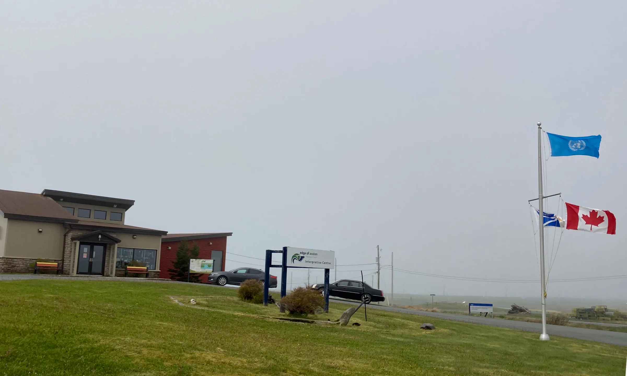
The building this drive ends at. OpenStreetMap tags it as a tourism information office. The province calls it the Mistaken Point Interpretation Centre, beside Route 10 in Portugal Cove South, and says the official guided tours leave from here. Bookings are at mistakenpoint.ca.
Directions →Show on map: Information Center Mistaken Point ↑Other map apps
Apple · Google · Organic Maps · OsmAnd (both work offline, no tracking) · Waze
Scan with your phone to open this page there. Then tap Keep for offline before you lose signal.
⛽ Fuel and gravel, road by road ▾
- Route 40 →Whole road: 6 fuel stations mapped, longest gap 5.7 km. Unpaved mapped: none; 28% has no surface tag, so unknown.
- Route 2 →Whole road: 10 fuel stations mapped, longest gap 28 km. Unpaved mapped: none; 70% has no surface tag, so unknown.
- Route 3 →Whole road: 1 fuel stations mapped, longest gap 9.2 km. Unpaved mapped: none; 1% has no surface tag, so unknown.
- Route 10 →Whole road: 7 fuel stations mapped, longest gap 91 km. Unpaved mapped: none; 77% has no surface tag, so unknown.
Drive measured Sep 5, 2026, St. John's International Airport (YYT) to Mistaken Point Interpretation Centre. Your maps app gives the time on the day. How we measure
Add to a trip →Staying here? Days out ↓Keep for offline ↓Download GPX (offline, Garmin)Airport info: St. John's International Airport →
About 144 km. St. John’s airport through the city, then Route 10, the Southern Shore Highway, down the coast to the interpretation centre at Portugal Cove South.
Book before you drive. Seeing the fossils is by guided tour or permit only; the province says reservations are mandatory and space is limited.
Why people come. Mistaken Point is a UNESCO World Heritage Site: a 565-million-year-old sea floor with, the province says, the oldest large, complex life-forms found anywhere on Earth.
When you get to Mistaken Point Interpretation Centre
- Where to eat near Mistaken Point Interpretation Centre → — 1 place the open map records, alphabetically, with addresses and phone numbers.
Sunrise and sunset at Mistaken Point Interpretation Centre, by month
| Month (the 15th) | Sunrise | Sunset |
|---|---|---|
| January | 7:43 am | 4:40 pm |
| February | 7:07 am | 5:26 pm |
| March | 7:17 am | 7:07 pm |
| April | 6:16 am | 7:49 pm |
| May | 5:28 am | 8:29 pm |
| June | 5:08 am | 8:58 pm |
| July | 5:23 am | 8:54 pm |
| August | 6:00 am | 8:15 pm |
| September | 6:39 am | 7:16 pm |
| October | 7:19 am | 6:17 pm |
| November | 7:05 am | 4:30 pm |
| December | 7:40 am | 4:15 pm |
Worked out for the 15th of each month at this spot, in local time. The weather line at the top has today's.
Places to eat on the way
52 near the start: where to eat in St. John's →
173 places to eat within 2 km of this drive, in the order you pass them.
The longest stretch with nothing mapped on it is 45.3 km — after Brophy's Convenience Plus (Jerome's), to Mistaken Point Interpretation Centre.
All 173, in the order you pass them — open the list
- Piattorestaurantkm 5.1 · 263 m off the road
- Wedgwood Cafe & Cateringrestaurantkm 5.1 · 429 m off the road
- Desi Mealrestaurantkm 5.3 · 399 m off the road
- Pizza Supremerestaurantkm 5.3 · 404 m off the road
- Sequerra's Restaurantrestaurantkm 5.3 · 395 m off the road
- Bitterspubkm 5.4 · 1461 m off the road
- Jumping Beancafékm 5.4 · 336 m off the road
- Big Bite Pitafast foodkm 5.7 · 947 m off the road
- MajesTeacafékm 5.7 · 941 m off the road
- Robin's Donutsfast foodkm 5.9 · 1957 m off the road
- Gracie Joe'srestaurantkm 6.3 · 957 m off the road
- Breezewaypubkm 6.5 · 1888 m off the road
- Ziggy Peelgoodfast foodkm 6.5 · 977 m off the road
- Tim Hortonscafékm 6.5 · 897 m off the road
- Donati'sfast foodkm 6.5 · 862 m off the road
- Pop's Dinerrestaurantkm 6.5 · 926 m off the road
- NJ's Kitchenrestaurantkm 6.5 · 884 m off the road
- Jumping Beancafékm 6.5 · 1811 m off the road
- Tim Hortonscafékm 6.5 · 1967 m off the road
- Mary Brown'sfast foodkm 6.5 · 1839 m off the road
- Booster Juicefast foodkm 6.5 · 1834 m off the road
- Manchu Wokfast foodkm 6.5 · 1828 m off the road
- Pizza Delightrestaurantkm 6.5 · 1819 m off the road
- Just Friesfast foodkm 6.5 · 1815 m off the road
- Smitty'srestaurantkm 6.5 · 910 m off the road
- Noodle Namirestaurantkm 6.5 · 889 m off the road
- Subwayfast foodkm 6.5 · 1074 m off the road
- Quintana'srestaurantkm 6.5 · 1036 m off the road
- Big Ben's Pubpubkm 6.5 · 1026 m off the road
- The Georgetown Pubpubkm 6.7 · 356 m off the road
- Beavertailsfast foodkm 6.8
- Georgestown Cafe and Bookshelfcafékm 6.8 · 335 m off the road
- The Parlourrestaurantkm 6.9 · 186 m off the road
- Hungry Heartcafékm 7
- Sun Sushi & Bubbled Tearestaurantkm 7.1 · 312 m off the road
- Get Stuffedrestaurantkm 7.1 · 305 m off the road
- Fixed Coffee and Bakingcafékm 7.1 · 339 m off the road
- Smitty'srestaurantkm 7.1 · 445 m off the road
- Portobello's Restaurantrestaurantkm 7.1 · 493 m off the road
- International Flavoursrestaurantkm 7.1 · 864 m off the road
- Classic Cafe Eastcafékm 7.1 · 587 m off the road
- Coffee Matterscafékm 7.1 · 515 m off the road
- J Korean Restaurantrestaurantkm 7.1 · 301 m off the road
- Zachary's Restaurantrestaurantkm 7.1 · 590 m off the road
- Chatters Coffeecafékm 7.1 · 490 m off the road
- Newfoundland Chocolate Cafecafékm 7.1 · 1570 m off the road
- Pirestaurantkm 7.1 · 307 m off the road
- Battery Cafecafékm 7.1 · 840 m off the road
- Bannerman Brewing Co.pubkm 7.1 · 548 m off the road
- Peaceful Loftrestaurantkm 7.2 · 259 m off the road
- Bamboo Gardenrestaurantkm 7.2 · 258 m off the road
- Bagel Caferestaurantkm 7.2 · 260 m off the road
- Fat Nanny'scafékm 7.2 · 283 m off the road
- Shalimarrestaurantkm 7.3 · 223 m off the road
- Oliver'srestaurantkm 7.4 · 261 m off the road
- Water St.Varietycafékm 7.4 · 301 m off the road
- Smoke's Poutinefast foodkm 7.4 · 283 m off the road
- Biancarestaurantkm 7.4 · 274 m off the road
- The Fifth Ticketrestaurantkm 7.4 · 275 m off the road
- Ship Pubpubkm 7.4 · 241 m off the road
- No.4 Restaurant & Barrestaurantkm 7.4 · 170 m off the road
- India Gaterestaurantkm 7.4 · 188 m off the road
- Saltwaterrestaurantkm 7.4 · 191 m off the road
- 3 Sisters Vietnamese Subsfast foodkm 7.5 · 210 m off the road
- Duke of Duckworthpubkm 7.5 · 173 m off the road
- Cojones Tacos & Tequilarestaurantkm 7.5 · 246 m off the road
- Sushi Islandrestaurantkm 7.6 · 202 m off the road
- Jumping Bean Coffeecafékm 7.6 · 191 m off the road
- Tim Hortonscafékm 7.6 · 265 m off the road
- The Sprout Restaurantrestaurantkm 7.7
- Ziggy Peelgoods French Friesfast foodkm 7.7 · 180 m off the road
- Chinchedrestaurantkm 7.7
- Yellowbelly Brewerypubkm 7.8
- The Kegrestaurantkm 7.8 · 214 m off the road
- Afghan Restaurantrestaurantkm 7.8
- Piatto Restaurantrestaurantkm 7.8
- The Republicpubkm 7.8
- Jack Astor'srestaurantkm 7.8 · 225 m off the road
- O'Reilly'spubkm 7.8
- Trapper John's Museum & Pubpubkm 7.8
- Rob Roy Pubpubkm 7.8
- Green Sleeves Pub & Restaurantpubkm 7.8
- Formosa Tea Houserestaurantkm 7.8 · 327 m off the road
- Celtic Hearthrestaurantkm 7.8
- Bridie Molloy’spubkm 7.8
- Merchant Tavernrestaurantkm 7.8
- Carribean Cornerrestaurantkm 7.8
- LIVrestaurantkm 7.8
- Frugal Steinsrestaurantkm 7.8
- Saltwaterrestaurantkm 7.8
- Black Cat Pizzeriarestaurantkm 7.8 · 324 m off the road
- Leo's Fish and Chipsfast foodkm 7.8 · 426 m off the road
- Ches' Fish & Chipsfast foodkm 7.8 · 380 m off the road
- Fat Bastard Burritofast foodkm 7.9
- Downtown Pizza fast foodkm 7.9
- Kelly's Pubpubkm 7.9
- Shamrock City Pubpubkm 7.9
- Christian'spubkm 7.9
- Adelaide Oyster Houserestaurantkm 7.9
- Gahan Housepubkm 7.9 · 205 m off the road
- Subwayfast foodkm 7.9
- Chinched Bistrorestaurantkm 8
- Fiddlers Pubpubkm 8
- Fabulous Foodsrestaurantkm 8 · 903 m off the road
- McDonald'sfast foodkm 8.2 · 1887 m off the road
- The Guv'nor Pubpubkm 8.2 · 1948 m off the road
- Humphreys Restaurant and Pubrestaurantkm 8.3
- Subwayfast foodkm 8.5 · 1492 m off the road
- RJ Pinoy Yumrestaurantkm 8.5 · 1506 m off the road
- No Name Pizzafast foodkm 8.5 · 1485 m off the road
- Ziggy Peelgoodsfast foodkm 8.5 · 1453 m off the road
- Mr. Subfast foodkm 8.5 · 1614 m off the road
- Tim Hortonscafékm 8.5 · 1537 m off the road
- Burger Kingfast foodkm 8.5 · 1562 m off the road
- KFCfast foodkm 8.5 · 1592 m off the road
- The Station Loungepubkm 8.6
- The Cove Climbing Cafécafékm 9.7 · 842 m off the road
- Tim Hortonscafékm 9.7 · 360 m off the road
- The Big R Restaurantrestaurantkm 10.8 · 1181 m off the road
- Mary Brown'sfast foodkm 11.2 · 1322 m off the road
- Domino'sfast foodkm 11.3 · 1470 m off the road
- Wendy'sfast foodkm 12.3 · 940 m off the road
- Peter's Pizzarestaurantkm 13.1 · 1175 m off the road
- Red Pepperrestaurantkm 13.1 · 1187 m off the road
- Subwayfast foodkm 13.1 · 1079 m off the road
- Rack and Roll Lounge and Games Roompubkm 13.2 · 1279 m off the road
- Burger Kingfast foodkm 13.3 · 967 m off the road
- McDonald'sfast foodkm 13.3 · 958 m off the road
- Tim Hortonscafékm 13.3 · 937 m off the road
- Tim Hortonscafékm 13.3
- Mary Brown'sfast foodkm 13.8 · 1379 m off the road
- Mary Brown'sfast foodkm 13.8 · 1386 m off the road
- New Moon Restaurantrestaurantkm 14.8 · 1493 m off the road
- Ches's Fish and Chipsfast foodkm 14.8 · 1335 m off the road
- Tim Hortonscafékm 14.8 · 1452 m off the road
- Topsail Road Pizzeria and Loungefast foodkm 14.8 · 1460 m off the road
- Big Cheese Pizzafast foodkm 14.8 · 1354 m off the road
- Jungle Jim'srestaurantkm 14.8 · 1351 m off the road
- Sushi Makirestaurantkm 14.8 · 1351 m off the road
- Dairy Queenfast foodkm 14.8 · 1476 m off the road
- Starbuckscafékm 14.8 · 1463 m off the road
- Redrock Bar & Grillrestaurantkm 14.8 · 1503 m off the road
- Jasmine's Restaurantrestaurantkm 14.9 · 1593 m off the road
- The Sweet Newfie Kitchenfast foodkm 16.1 · 1922 m off the road
- Oscars Eatery & Caférestaurantkm 16.1 · 1833 m off the road
- Subwayfast foodkm 17.4 · 1460 m off the road
- Extreme Pitafast foodkm 17.4 · 1691 m off the road
- Pizza Delightrestaurantkm 17.4 · 1506 m off the road
- Smitty'srestaurantkm 17.4 · 1521 m off the road
- McDonald'sfast foodkm 17.4 · 1895 m off the road
- Harvey'sfast foodkm 17.4 · 1525 m off the road
- Tim Hortonscafékm 17.4 · 1479 m off the road
- Asian Caferestaurantkm 17.4 · 1981 m off the road
- Landwash Brewerypubkm 17.4 · 832 m off the road
- Thaï Expressfast foodkm 17.4 · 1532 m off the road
- Johny & Mae'sfast foodkm 17.4 · 827 m off the road
- Booster Juicefast foodkm 17.4 · 1535 m off the road
- Tim Hortonscafékm 17.4 · 1485 m off the road
- Harvey'sfast foodkm 17.4 · 1526 m off the road
- Little Caesarsfast foodkm 18.9 · 1592 m off the road
- Dairy Queenfast foodkm 18.9 · 1570 m off the road
- Tim Hortonscafékm 21.7 · 1882 m off the road
- Jungle Jimsrestaurantkm 21.8 · 1802 m off the road
- Subwayfast foodkm 21.8 · 1825 m off the road
- Keith's Dinerrestaurantkm 22.2 · 1788 m off the road
- Mary Brownsrestaurantkm 22.2 · 1718 m off the road
- Tim Hortonscafékm 42
- The Captain's Tablerestaurantkm 46.1
- Riverside Restaurant and Loungerestaurantkm 73.7
- Bernard Kavanagh's Restaurantrestaurantkm 83.5
- Lighthouse Picnicsrestaurantkm 84.9
- In Da Loop Restaurant & Pubpubkm 97.7
- Brophy's Convenience Plus (Jerome's)restaurantkm 98.4
Not ranked or complete, and nobody pays to be here. No opening hours: phone ahead. Open map data, swept 2026-09-12. How we measure · Add a missing place
New place to eat, or one that's missing? This list comes from OpenStreetMap, so nobody can pay to be on it. Add it to the map yourself (about twenty minutes on a phone), or email us the details and we'll put it on the map.
What has been recorded near here
Wildlife people have reported within 10 km of Mistaken Point Interpretation Centre, and the months they saw it. Tap a name for everywhere else on our drives it turns up.
- Northern gannetseabirdMorus bassanusReports cluster in July, August, June712 reports on record
- Atlantic puffinseabirdFratercula arcticaReports cluster in July, August, June136 reports on record
Reports, not counts: busy harbours report more. No sighting is promised, and the list covers only the species we look up. Source: GBIF, the international record of wildlife sightings, checked 2026-10-07.
Short drives from Mistaken Point Interpretation Centre
Other map apps
Apple · Google · Organic Maps · OsmAnd (both work offline, no tracking) · WazeOr any of these: nearest first, measured by road from Mistaken Point Interpretation Centre.
- Trepasseytown12 kmDirections →
Other map apps
Apple · Google · Organic Maps · OsmAnd (both work offline, no tracking) · Waze - Cape Race Lighthouselighthouse21 kmDirections →
Other map apps
Apple · Google · Organic Maps · OsmAnd (both work offline, no tracking) · Waze - Cape Pine Lighthouselighthouse40 kmDirections →
Other map apps
Apple · Google · Organic Maps · OsmAnd (both work offline, no tracking) · Waze
Distances by road, measured on OpenStreetMap October 16, 2026, from where this route ends. Your maps app gives the time on the day. How we measure
Doing it electric
- Fast chargers on this drive
- Fermeuse km 98
- Longest stretch without one
- 98 km
- St. John's → Fermeuse, of 144 km driven
- Nearest fast charger to Mistaken Point Interpretation Centre
- 11.7 km
- by road, at Trepassey
NL Hydro fast chargers within 3 km of the drive. Check the app for one that's working. Exported 2026-10-22. How we measure
Paved or not, per the map
- Mapped as unpaved
- none
- Not proof it is all paved: 84% has no surface tag.
- Mapped as paved
- 16%
- 21.9 km of 144.2 km driven
- No surface tag on the map
- 84%
- 112.7 km: surface not recorded
In a rental car: Hertz Canada’s terms say “use off paved roads or on roads which are not regularly maintained” voids the damage waiver. Check your own agreement. Hertz’s terms ↗. Source for these figures: OSRM driving profile, stored route query, with node annotations; OpenStreetMap surface tags via Overpass, checked 2026-09-13. Today's road conditions: 511.
Before you go
These change, so we link to the people who keep them up to date.
MooseYear round, worst between dusk and dawn
The province states the likelihood of injury in a moose collision is twice as high between dusk and dawn as in daytime. Once clear of St. John's it is Route 10, the Southern Shore Highway, all the way; OpenStreetMap tags it two-lane primary highway at every point we sampled. Land in the evening and the risk covers most of the drive.
gov.nl.ca →Road conditionsYear round, matters most November–April
Route 10 runs down an exposed coast to Portugal Cove South, near what the province calls the often-foggy southeastern tip of the Avalon Peninsula. It tells visitors to expect cool, windy, wet and foggy conditions. Check conditions before you leave the airport.
511nl.ca →Getting into the reserveStanding rules from the province
The province says the fossils can be seen by guided tour or permit only. Motor vehicles, bicycles and horses are not allowed in the reserve, and removing or trying to remove fossils is prohibited. It names two trails you can walk without a tour: the Rookery, out to cliffs where seabirds nest and whales can be seen, and Freshwater, across the barrens to the water's edge. It advises carrying a compass on either.
gov.nl.ca →Seeing the fossilsSeasonal — check current dates and availability
The province runs its tours for part of the year only. Space is limited, reservations are mandatory, and it asks visitors to book well ahead at mistakenpoint.ca. Confirm your booking before you commit to the day's drive.
mistakenpoint.ca →
Renting a car? Book the car when you book the flight.
Summer rentals sell out, says NL Tourism, and in June 2026 BNN Bloomberg reported St. John's airport agencies booked for nearly all of summer.
Both checked October 7, 2026.
Rental counters at St. John's, with numbers →Arriving without a car
Not renting? Here's who St. John's International Airport Authority lists at the terminal.
Rideshare: it depends who you ask.
The Airport Authority's own ground-transportation pages name City Wide Taxi as “the exclusive provider of ground transportation services for the public” and do not mention rideshare anywhere. Uber publishes pickup instructions for YYT, and the Airport's own account welcomed Uber in 2024. Both are true. The Authority's pages govern the kerb, so check them on the day.
Taxi
City Wide Taxi, which the Airport Authority names as the exclusive provider for the public. Cabs queue outside the Arrivals area and a dispatcher is there to help. The Authority publishes preset fares to named hotels and a meter-plus-surcharge rate everywhere else.
Public transit
Metrobus route 14 runs between the airport and the St. John's metro region, including Memorial University. There are two stops at the airport: one near the arrivals area, and one on World Parkway by the Holiday Inn Express. The Authority says Metrobus has committed to a wheelchair-accessible service on this route and can take large, non-folding mobility aids. Schedule and fares are Metrobus's.
Source: St. John's International Airport Authority,2026-09-15. Check there for fares and times.
The drive back
Measured the other way, Mistaken Point Interpretation Centre back to St. John's is the same distance: 145 km.
Plan back from your check-in time. Give the planner your flight time and it tells you when to set off.
How early to arrive depends on the carrier and the season: check St. John's International Airport →
Return measured 2026-09-29, the same way as the drive out. How we measure
Questions
How far is Mistaken Point from St. John's airport?+
About 144 km, on Routes 40, 2, 3 and 10: through St. John's past the waterfront, then Route 10 down the Southern Shore to Portugal Cove South, the closest community to the reserve.
Should I fly into St. John's, Gander or Deer Lake for Mistaken Point?+
St. John's, by a wide margin. It is 144 km from St. John's, against 406 km from Gander and 709 km from Deer Lake. The reserve is at the southeastern tip of the Avalon Peninsula, where St. John's airport also sits.
Can I just drive down and see the fossils?+
No. The province says access is by guided tour or permit only, and tour reservations are mandatory because tours are often fully booked in advance. The tour leaves from the interpretation centre this drive ends at, continues in your own vehicle to the trailhead, and finishes on foot. The province rates that walk moderately difficult, over uneven, wet ground with some scrambling over rocks.
What is Mistaken Point?+
A provincial ecological reserve, protected since 1987, and a UNESCO World Heritage Site since 2016. The province calls it the best place in the world to view a 565-million-year-old sea floor. Its rock layers carry fossils of the Ediacara biota, soft-bodied creatures that, in the province's words, lived millions of years before animals developed skeletons. They were first recorded here in 1967, the first Ediacara-type fauna found in the Western Hemisphere.
Is it a hard drive?+
No. Most of it is Route 10, which OpenStreetMap tags as two-lane primary road at every point we sampled (way/1098779593, way/831064321 and way/831064312). It is long and undivided, so plan around driving it after dark: see the moose note above.
No recorded track yet.Drove it? Send yours →
Put this map on your site
Run a place to stay, a tour or a town page on this drive? Add this map to your site. It shows your guests the drive and its distance. It is free, needs no account, and we keep the figures current.
<iframe src="https://fromtheairport.xyz/embed/yyt-mistaken-point"
  width="100%" height="420" style="border:0" loading="lazy"
title="Driving route: St. John's International Airport (YYT) to Mistaken Point Interpretation Centre"></iframe>?lat=&lon=&label= to the URL to pin your own property on the map.Every distance and coordinate on this page was checked against its source on September 30, 2026. Origin: OpenStreetMap way/279110348 — St. John's International Airport. Destination: OpenStreetMap way/125041120 — Information Center Mistaken Point.