Gander International Airport (YQX) → Greenspond
Gander Airport (YQX) to Greenspond
The drive from every airport and ferry ↓
- Distance
- 124.3 km
- Drive time
- In your maps app ↗
Use another map app
Apple Maps · Google Maps · Organic Maps · OsmAnd (both work offline, no tracking) · Waze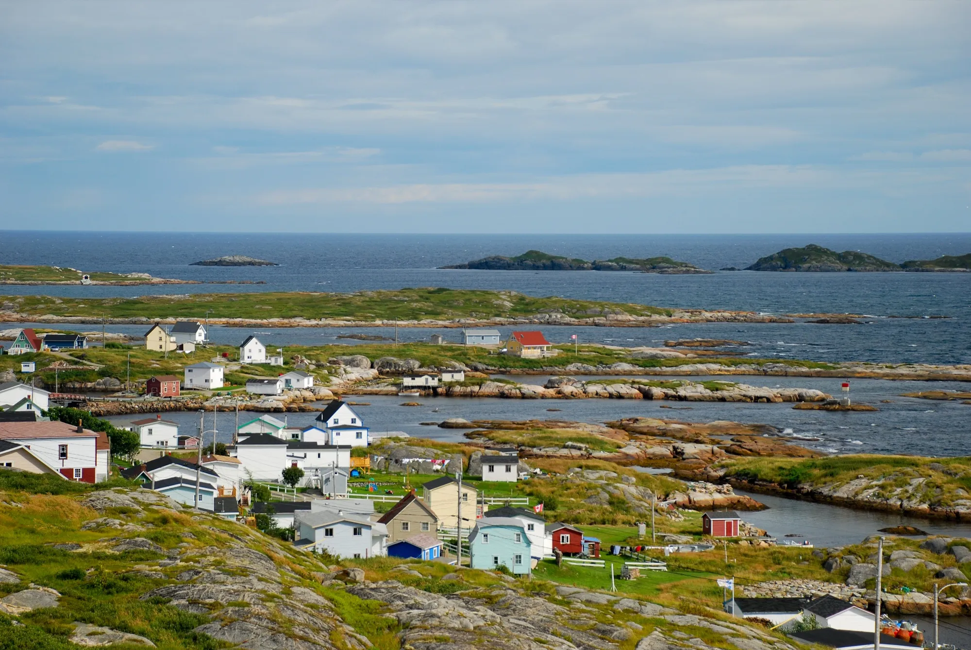

Faded lines are other drives from Gander International into this area: New-Wes-Valley (119 km), Dover (73 km), Burnside ferry terminal (94 km), Salvage (97 km). Each splits off where its line leaves this one.
Stop 1: Joey's Lookout (Gambo)
The viewpoint above Joey Smallwood's hometown, right off the highway, on every drive down this side of the island.
Stopping here adds 0.1 km to the drive.
Directions →Show on map: Joey's Lookout (Gambo) ↑Other map apps
Apple · Google · Organic Maps · OsmAnd (both work offline, no tracking) · WazeStop 2: Square Pond
A pond-side stop beside the Trans-Canada. OpenStreetMap still uses its old provincial-park name; the province no longer lists it. A place to stretch your legs.
Stopping here adds 0.7 km to the drive.
Directions →Show on map: Square Pond ↑Other map apps
Apple · Google · Organic Maps · OsmAnd (both work offline, no tracking) · WazeStop 3: Greenspond Courthouse
Mapped as a museum: the island's 19th-century courthouse, kept as a heritage site. It is on the island itself.
Stopping here adds 0.5 km to the drive.
Directions →Show on map: Greenspond Courthouse ↑Other map apps
Apple · Google · Organic Maps · OsmAnd (both work offline, no tracking) · Waze
Scan with your phone to open this page there. Then tap Keep for offline before you lose signal.
⛽ Fuel and gravel, road by road ▾
- Route 330 →Whole road: 8 fuel stations mapped, longest gap 42 km. Unpaved mapped: none; 70% has no surface tag, so unknown.
- Route 1 →Whole road: 54 fuel stations mapped, longest gap 119 km. Unpaved mapped: none; 68% has no surface tag, so unknown.
- Route 320 →Whole road: 6 fuel stations mapped, longest gap 39 km. Unpaved mapped: none; 72% has no surface tag, so unknown.
Drive measured Sep 3, 2026, terminal to the island. Your maps app gives the time on the day. How we measure
Add to a trip →Staying here? Days out ↓Keep for offline ↓Download GPX (offline, Garmin)Airport info: Gander International Airport →
124 km. Gander airport to Greenspond: mostly easy Trans-Canada, then Route 320 to the causeway onto the island.
Why people come. An old island outport, with its 19th-century courthouse kept as a museum and Puffin Island’s lighthouse offshore.
Pair it with New-Wes-Valley one bay north, or Musgrave Harbour’s sand beyond it along Route 330.
When you get to Greenspond
- Where to eat near Greenspond → — 1 place the open map records, alphabetically, with addresses and phone numbers.
Sunrise and sunset at Greenspond, by month
| Month (the 15th) | Sunrise | Sunset |
|---|---|---|
| January | 7:53 am | 4:32 pm |
| February | 7:13 am | 5:23 pm |
| March | 7:19 am | 7:08 pm |
| April | 6:13 am | 7:54 pm |
| May | 5:22 am | 8:38 pm |
| June | 4:58 am | 9:10 pm |
| July | 5:15 am | 9:04 pm |
| August | 5:55 am | 8:22 pm |
| September | 6:39 am | 7:19 pm |
| October | 7:23 am | 6:15 pm |
| November | 7:13 am | 4:24 pm |
| December | 7:52 am | 4:07 pm |
Worked out for the 15th of each month at this spot, in local time. The weather line at the top has today's.
Places to eat on the way
28 near the start: where to eat in Gander →
2 near Greenspond: where to eat near Greenspond →
6 places to eat within 2 km of this drive, in the order you pass them.
The longest stretch with nothing mapped on it is 36.1 km — after Family Pizza, until Washed Ashore.
Every one of them, in the order you pass them
- Copper Kettle Restaurantrestaurantkm 31.9
- Family Pizzarestaurantkm 48.7
- Washed Ashorecafékm 84.8
- Aunt Hannah's Cafe and Gallerycafékm 89.3
- Sunset Grillrestaurantkm 89.5
- Silver Fox Loungecafékm 90.1
Not ranked or complete, and nobody pays to be here. No opening hours: phone ahead. Open map data, swept 2026-09-12. How we measure · Add a missing place
New place to eat, or one that's missing? This list comes from OpenStreetMap, so nobody can pay to be on it. Add it to the map yourself (about twenty minutes on a phone), or email us the details and we'll put it on the map.
What has been recorded near here
Wildlife people have reported within 10 km of Greenspond, and the months they saw it. Tap a name for everywhere else on our drives it turns up.
- Northern gannetseabirdMorus bassanusReports cluster in July, August, September33 reports on record
Reports, not counts: busy harbours report more. No sighting is promised, and the list covers only the species we look up. Source: GBIF, the international record of wildlife sightings, checked 2026-10-07.
Short drives from Greenspond
Other map apps
Apple · Google · Organic Maps · OsmAnd (both work offline, no tracking) · WazeOr any of these: nearest first, measured by road from Greenspond.
- New-Wes-Valleytown25 kmDirections →
Other map apps
Apple · Google · Organic Maps · OsmAnd (both work offline, no tracking) · Waze - Newtown Boardwalk Walktrail · 3.4 km walk · easy38 kmDirections →
Other map apps
Apple · Google · Organic Maps · OsmAnd (both work offline, no tracking) · Waze - Windmill Bight Park Reservestop44 km
Three kilometres from Lumsden off Route 330.
Directions →Other map apps
Apple · Google · Organic Maps · OsmAnd (both work offline, no tracking) · Waze
Distances by road, measured on OpenStreetMap October 16, 2026, from where this route ends. Your maps app gives the time on the day. How we measure
Doing it electric
- Fast chargers on this drive
- Gander km 3
- Longest stretch without one
- 121 km
- Gander → Greenspond, of 124 km driven
- Nearest fast charger to Greenspond
- 106.5 km
- by road, at Glowertown
No fast charger at Greenspond. From Gander it is 121 km there and the same back: plan on about 242 km on one charge, more in cold weather or with the heat on. Or charge at Glowertown, 106.5 km from Greenspond by road, off this drive's own road.
Coming in 2026 (NL Hydro, 2026-10-22): Gander (km 2). Not counted until it opens.
NL Hydro fast chargers within 3 km of the drive. Check the app for one that's working. Exported 2026-10-22. How we measure
Paved or not, per the map
- Mapped as unpaved
- 0.4 km
- Cemetary Road (0.07 km, 0 km from Greenspond); Cemetery Road (0.3 km, 0.2 km from Greenspond)
- Mapped as paved
- 23%
- 26.4 km of 124.3 km driven
- No surface tag on the map
- 77%
- 87.8 km: surface not recorded
In a rental car: Hertz Canada’s terms say “use off paved roads or on roads which are not regularly maintained” voids the damage waiver. Check your own agreement. Hertz’s terms ↗. Source for these figures: OSRM driving profile, stored route query, with node annotations; OpenStreetMap surface tags via Overpass, checked 2026-09-06. Today's road conditions: 511.
Before you go
These change, so we link to the people who keep them up to date.
MooseYear round, worst between dusk and dawn
The province states that the likelihood of injury in a moose collision is twice as high between dusk and dawn as in daytime. Route 320 north of the Trans-Canada is long, low and wooded.
gov.nl.ca →Road conditionsYear round, matters most November–April
The causeway is the island's one road link. In wind and winter, check before you head for the coast.
511nl.ca →
Renting a car? Book the car when you book the flight.
Summer rentals sell out, says NL Tourism, and in June 2026 BNN Bloomberg reported St. John's airport agencies booked for nearly all of summer.
Both checked October 7, 2026.
Rental counters at Gander, with numbers →Arriving without a car
Not renting? Here's who Gander International Airport Authority lists at the terminal.
No rideshare here.
The Airport Authority's transport page lists no rideshare service (checked 2026-09-15).
Taxi
Busy Bee Cabs, which the Airport Authority says runs a 24-hour service available curbside in the Domestic Arrivals area.
Coach
DRL Coachlines runs the island's one scheduled coach, once a day each way, between St. John's and the Marine Atlantic terminal at Port aux Basques. It stops at Gander Airport itself (the restaurant), and at Lewisporte, Grand Falls-Windsor, Deer Lake and Corner Brook among others. It reaches no island and no national park. Tickets are bought on the bus, cash only. The Airport Authority says a wheelchair-accessible bus needs 48 hours' notice. Times and fares are DRL's: drl-lr.com.
Limousine
Nobel Limousines, listed by the Airport Authority.
Avis, Budget, National and Enterprise are listed at the airport. The Authority says accessible vehicles with wheelchair accommodation or hand controls are limited and need 48 hours' notice.
Source: Gander International Airport Authority,2026-09-15. Check there for fares and times.
The drive back
Measured the other way, Greenspond back to Gander is the same distance: 124 km.
Plan back from your check-in time. Give the planner your flight time and it tells you when to set off.
How early to arrive depends on the carrier and the season: check Gander International Airport →
Return measured 2026-09-29, the same way as the drive out. How we measure
Questions
Should I fly into Gander or Deer Lake for Greenspond?+
Gander: 124 km against 427 km from Deer Lake. Gander is the airport for the whole Route 320 coast.
What is Greenspond?+
An island outport, one of the oldest continuously inhabited on this coast. Most accounts say it was settled in the 1690s. A causeway joined it to the mainland only in living memory.
What is the drive actually like?+
Trans-Canada east past Gambo, Route 320 north through Indian Bay country, then the coast opens. The last kilometres run the shore to the causeway, and the road ends among wharves and painted houses on an island settled two and a half centuries before the airport existed.
Is there a lighthouse?+
Offshore, yes. Puffin Island Lighthouse is mapped on its own island just off Greenspond's harbour. You view it from the shore; no road reaches it.
No recorded track yet.Drove it? Send yours →
Put this map on your site
Run a place to stay, a tour or a town page on this drive? Add this map to your site. It shows your guests the drive and its distance. It is free, needs no account, and we keep the figures current.
<iframe src="https://fromtheairport.xyz/embed/yqx-greenspond"
  width="100%" height="420" style="border:0" loading="lazy"
title="Driving route: Gander International Airport (YQX) to Greenspond"></iframe>?lat=&lon=&label= to the URL to pin your own property on the map.Every distance and coordinate on this page was checked against its source on September 3, 2026. Origin: OpenStreetMap way/154350645 — passenger terminal. Destination: OpenStreetMap node/107363353 — Greenspond place node.