A loop from Clarenville
Discovery Trail
Getting to the start from every airport and ferry ↓
- Distance
- 304.6 km
- Drive time
- In your maps app ↗
Google Maps is the one app that takes a loop's stops in order from a link. In another app, drive it stop by stop from the list below.

Stop 1: Random PassageDetour
The set of the TV miniseries Random Passage at New Bonaventure, a replica of an early 1800s fishing village, per the province's tourism site. OpenStreetMap maps its admission and tearoom.
Stopping here adds 27.8 km to the drive.
Directions →Show on map: Random Passage ↑Other map apps
Apple · Google · Organic Maps · OsmAnd (both work offline, no tracking) · WazeStop 2: Trinity Museum
The town's own museum. The province's tourism site counts about 350 permanent residents and some 50 architecturally significant buildings in Trinity, and names the Cooperage and a working forge among its exhibits. Check hours with the museum.
Directions →Show on map: Trinity Museum ↑Other map apps
Apple · Google · Organic Maps · OsmAnd (both work offline, no tracking) · WazeStop 3: Skerwink Trail lookoutDetour
A lookout on the Skerwink Trail at Port Rexton, which Travel + Leisure listed among the 25 best hikes in North America and Europe, per the province's tourism site. The trail passes a sea stack called the Music Box; the province names kittiwakes, gannets and whales among what you can see from it.
Stopping here adds 5.2 km to the drive.
Directions →Show on map: Skerwink Trail lookout ↑Other map apps
Apple · Google · Organic Maps · OsmAnd (both work offline, no tracking) · WazeStop 4: Port Union
A town built by a union and founded by the fishermen's leader Sir William Coaker, as the province's tourism site tells it. Its boardwalk is part of the Discovery UNESCO Global Geopark, with fossils from the Ediacaran Period.
Directions →Show on map: Port Union ↑Other map apps
Apple · Google · Organic Maps · OsmAnd (both work offline, no tracking) · WazeStop 5: Elliston Puffin Viewing PointDetour
The province's tourism site calls this the closest view of puffins from land anywhere: the birds often land on the cliffs a few feet away. In season only.
Stopping here adds 3.5 km to the drive.
Directions →Show on map: Elliston Puffin Viewing Point ↑Other map apps
Apple · Google · Organic Maps · OsmAnd (both work offline, no tracking) · WazeStop 6: John C. Crosbie Sealers Interpretation Centre
Opened at Elliston in June 2014, a hundred years after the disaster it exists for. On 30 March 1914 sealers from the SS Newfoundland were left on the ice in a blizzard, and the SS Southern Cross went down the same day returning from the front; more than 250 men were lost between them. Elliston lost a greater share of its men than any other community, so the centre is here.
Directions →Show on map: John C. Crosbie Sealers Interpretation Centre ↑Other map apps
Apple · Google · Organic Maps · OsmAnd (both work offline, no tracking) · WazeStop 7: The root cellars at Elliston
A root cellar keeps vegetables from freezing in winter and cool in summer, and was ordinary domestic infrastructure before electricity. Elliston has enough still standing to be known for them. The town points visitors to an upstairs/downstairs pair built in 1915. They are on the roadside and free to see.
Directions →Show on map: The root cellars at Elliston ↑Other map apps
Apple · Google · Organic Maps · OsmAnd (both work offline, no tracking) · WazeStop 8: Dungeon Provincial ParkDetour
A ParksNL day-use park around a collapsed sea cave, now a steep-sided crater with two ocean windows, in a sheep pasture near Cape Bonavista.
Stopping here adds 3.5 km to the drive.
Directions →Show on map: Dungeon Provincial Park ↑Other map apps
Apple · Google · Organic Maps · OsmAnd (both work offline, no tracking) · WazeStop 9: Cape Bonavista Lighthouse
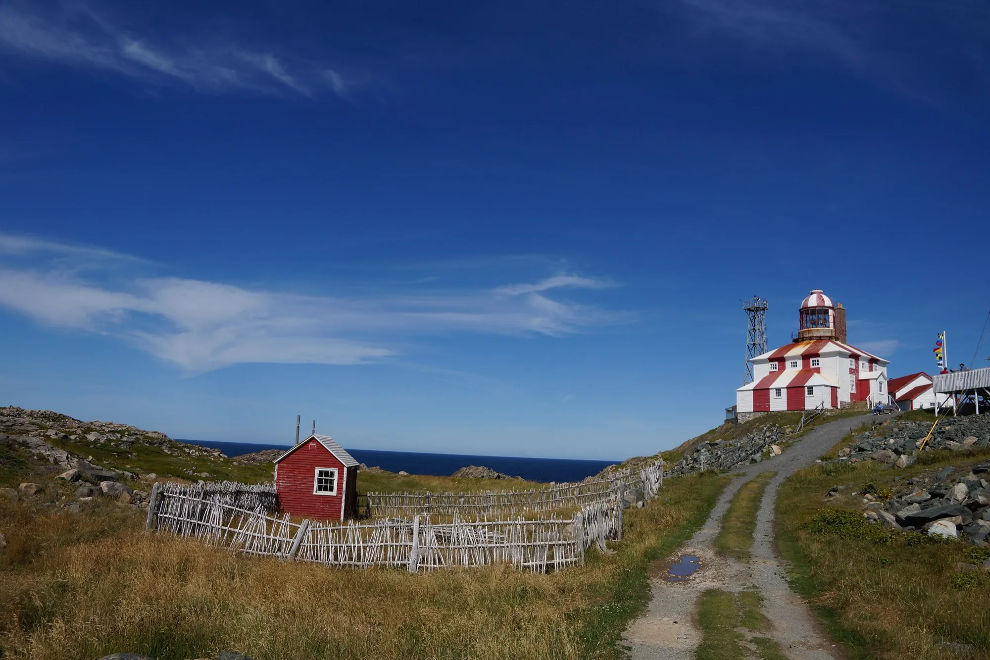
The top of the circle: the road up the peninsula ends at a lighthouse on the cape. From here the way home runs south down the Bonavista Bay side. It is a provincial historic site with its own season, so check with the operator whether the building is open. The cape and the view are there whatever the date.
Directions →Show on map: Cape Bonavista Lighthouse ↑Other map apps
Apple · Google · Organic Maps · OsmAnd (both work offline, no tracking) · WazeStop 10: Mockbeggar Plantation
A provincial historic site and the legacy of F. Gordon Bradley, Newfoundland's first federal cabinet minister after Confederation: a restored outport merchant's house and outbuildings, among them a former cod liver oil factory, per the province's tourism site.
Stopping here adds 1.6 km to the drive.
Directions →Show on map: Mockbeggar Plantation ↑Other map apps
Apple · Google · Organic Maps · OsmAnd (both work offline, no tracking) · WazeStop 11: Ryan Premises National Historic Site
Parks Canada's site on Bonavista's waterfront: a restored fish merchant's premises that tells five centuries of the fishery. Parks Canada publishes hours and season.
Directions →Show on map: Ryan Premises National Historic Site ↑Other map apps
Apple · Google · Organic Maps · OsmAnd (both work offline, no tracking) · Waze
Scan with your phone to open this page there. Then tap Keep for offline before you lose signal.
⛽ Fuel and gravel, road by road ▾
- Route 230 →Whole road: 8 fuel stations mapped, longest gap 45 km. Unpaved mapped: none; 4% has no surface tag, so unknown.
- Route 239 →Whole road: 0 fuel stations mapped, longest gap 17 km. Unpaved mapped: none; 0% has no surface tag, so unknown.
- Route 238 →Whole road: 1 fuel stations mapped, longest gap 12 km. Unpaved mapped: none; 36% has no surface tag, so unknown.
- Route 235 →Whole road: 5 fuel stations mapped, longest gap 33 km. Unpaved mapped: none; 2% has no surface tag, so unknown.
- Route 1 →Whole road: 54 fuel stations mapped, longest gap 119 km. Unpaved mapped: none; 68% has no surface tag, so unknown.
Drive measured Oct 11, 2026, Clarenville round by Trinity, Elliston, Cape Bonavista, Plate Cove East, Summerville, Musgravetown and Port Blandford. Your maps app gives the time on the day. How we measure
Staying here? Days out ↓Keep for offline ↓Download GPX (offline, Garmin)
304.6 km, all the way round. The province’s Discovery Trail has two ways onto the Bonavista peninsula, Route 230 at Clarenville and Route 233 at Port Blandford, and this circle uses both: up Route 230 through Trinity and Elliston to the lighthouse at the cape, then home down the Bonavista Bay side on Route 235, across on 233 through Musgravetown, and back along the Trans-Canada.
What you drive twice: about 17 km of Route 230 at the neck of the peninsula, which every road on and off it shares, and the short runs in to Trinity and out to the cape.
Not a day trip. That is 305 km of driving, before any stops.
Why the province says 425 km. It adds the side roads off the circle.
When you get to Clarenville
- Staying in Clarenville? → — the start page: short drives from town, food, and a planner that starts here.
- Where to eat near Clarenville → — 38 places the open map records, alphabetically, with addresses and phone numbers.
- Clarenville Events Centre → — the venue here, with what you can reach and be back from between games.
Sunrise and sunset at Clarenville, by month
| Month (the 15th) | Sunrise | Sunset |
|---|---|---|
| January | 7:51 am | 4:37 pm |
| February | 7:13 am | 5:26 pm |
| March | 7:20 am | 7:10 pm |
| April | 6:16 am | 7:54 pm |
| May | 5:26 am | 8:37 pm |
| June | 5:04 am | 9:07 pm |
| July | 5:20 am | 9:02 pm |
| August | 5:59 am | 8:21 pm |
| September | 6:41 am | 7:20 pm |
| October | 7:24 am | 6:18 pm |
| November | 7:12 am | 4:29 pm |
| December | 7:49 am | 4:12 pm |
Worked out for the 15th of each month at this spot, in local time. The weather line at the top has today's.
Places to eat on the way
14 near Clarenville: where to eat near Clarenville →
30 places to eat within 2 km of this drive, in the order you pass them.
The longest stretch with nothing mapped on it is 92.7 km — after Bonavista Social Club, until Restaurant.
Every one of them, in the order you pass them
- The Curtain Call Cafecafékm 7.3
- Robin's Donutsfast foodkm 23.8 · 153 m off the road
- Dunrovinrestaurantkm 25.1 · 173 m off the road
- Twine Loft Diningrestaurantkm 69.3
- The Vintage Grindcafékm 69.4
- Dock Marina restaurantrestaurantkm 70.1
- The Galleyrestaurantkm 77.5
- Port Rexton Brewerypubkm 78.7 · 714 m off the road
- Oh my Cheesesfast foodkm 78.7 · 726 m off the road
- 2 Whales cafecafékm 79.2
- Sea Breeze Takeoutfast foodkm 121.6 · 604 m off the road
- Puffin Cafécafékm 122.2
- Nanny's Root Cellar Kitchenrestaurantkm 122.6
- Oceanview Restaurantrestaurantkm 130.3
- Restaurant glace take outrestaurantkm 132.6
- PK's Restaurant and Take-Outrestaurantkm 140.2
- Ragged Rocks Gastropubpubkm 140.2
- The Quintal Cafécafékm 140.3
- The Boreal Dinerrestaurantkm 140.3
- Marsh's Snack Barrestaurantkm 140.4
- Mifflin's Tea Roomcafékm 140.6
- Mifflin's Tea Roomcafékm 140.6
- Bonavista Brewing Taproompubkm 140.6
- Bonavista Bicycle Picnics and Cafecafékm 140.8 · 597 m off the road
- Walkham's Gate Pub & Cafepubkm 140.8
- Neil's Yardcafékm 140.8 · 652 m off the road
- Robin's Donutsfast foodkm 142.3 · 942 m off the road
- Bonavista Social Clubcafékm 155.4 · 895 m off the road
- Restaurantfast foodkm 248.1
- Snack shack.fast foodkm 266.2
Not ranked or complete, and nobody pays to be here. No opening hours: phone ahead. Open map data, swept 2026-09-20. How we measure · Add a missing place
Short drives from Clarenville
Other map apps
Apple · Google · Organic Maps · OsmAnd (both work offline, no tracking) · WazeOr any of these: nearest first, measured by road from Clarenville.
- White Hills Resorttown8.5 kmDirections →
Other map apps
Apple · Google · Organic Maps · OsmAnd (both work offline, no tracking) · Waze - Dunphy's Pond Trailtrail · 9.8 km out and back · moderate44 kmDirections →
Other map apps
Apple · Google · Organic Maps · OsmAnd (both work offline, no tracking) · Waze - Ochre Hill Trailtrail · 5 km loop · easy63 kmDirections →
Other map apps
Apple · Google · Organic Maps · OsmAnd (both work offline, no tracking) · Waze - Sandy Pond Trailtrail · 3 km loop · easy63 kmDirections →
Other map apps
Apple · Google · Organic Maps · OsmAnd (both work offline, no tracking) · Waze - Outport Trailtrail · 35 km out and back · strenuous67 kmDirections →
Other map apps
Apple · Google · Organic Maps · OsmAnd (both work offline, no tracking) · Waze - Trinitytown70 kmDirections →
Other map apps
Apple · Google · Organic Maps · OsmAnd (both work offline, no tracking) · Waze - Coastal Trail (Terra Nova)trail · 8.4 km out and back · moderate72 kmDirections →
Other map apps
Apple · Google · Organic Maps · OsmAnd (both work offline, no tracking) · Waze - Mount Stamford Look-off Trailtrail · 2.2 km out and back · easy72 kmDirections →
Other map apps
Apple · Google · Organic Maps · OsmAnd (both work offline, no tracking) · Waze
More, up to 83 km (6)
- Goowiddy Pathtrail · 8 km loop · moderate72 kmDirections →
Other map apps
Apple · Google · Organic Maps · OsmAnd (both work offline, no tracking) · Waze - Lockston Path Provincial Parkstop72 km
The peninsula's ParksNL campground, just off Route 236 near Port Rexton, and the campground on this route.
Directions →Other map apps
Apple · Google · Organic Maps · OsmAnd (both work offline, no tracking) · Waze - Fort Point viewpointstop76 km
The mapped bench at Fort Point, across the harbour mouth, on the old gun battery's ground.
Directions →Other map apps
Apple · Google · Organic Maps · OsmAnd (both work offline, no tracking) · Waze - Louil Hill Trailtrail · 3.7 km loop · easy79 kmDirections →
Other map apps
Apple · Google · Organic Maps · OsmAnd (both work offline, no tracking) · Waze - Mill Cove Lookout Trailtrail · 1.6 km out and back · easy80 kmDirections →
Other map apps
Apple · Google · Organic Maps · OsmAnd (both work offline, no tracking) · Waze - Malady Head Trailtrail · 3.8 km out and back · easy83 kmDirections →
Other map apps
Apple · Google · Organic Maps · OsmAnd (both work offline, no tracking) · Waze
Distances by road, measured on OpenStreetMap October 16, 2026, from where this route ends. Your maps app gives the time on the day. How we measure
Doing it electric
- Fast chargers on this drive
- Port Rexton km 79, Bonavista km 143, Port Blandford km 273
- Longest stretch without one
- 130 km
- Bonavista → Port Blandford, of 304 km driven
- Nearest fast charger to Clarenville
- 29.3 km
- by road, at Goobies
Coming in 2026 (NL Hydro, 2026-10-22): Clarenville (km 303). Not counted until it opens.
NL Hydro fast chargers within 3 km of the drive. Check the app for one that's working. Exported 2026-10-22. How we measure
Paved or not, per the map
- Mapped as unpaved
- 1.3 km
- a residential road (0.17 km, 27.3 km from Clarenville); Main Street (0.47 km, 28.8 km from Clarenville); Old Point Road (0.3 km, 85.8 km from Clarenville)
- Mapped as paved
- 66%
- 161.2 km of 304.6 km driven
- No surface tag on the map
- 33%
- 80 km: surface not recorded
In a rental car: Hertz Canada’s terms say “use off paved roads or on roads which are not regularly maintained” voids the damage waiver. Check your own agreement. Hertz’s terms ↗. Source for these figures: OSRM driving profile, stored route query, with node annotations; OpenStreetMap surface tags via Overpass, checked 2026-10-11. Today's road conditions: 511.
Before you go
These change, so we link to the people who keep them up to date.
Cape Bonavista LighthouseA provincial historic site with a summer season — dates are the operator’s
The lighthouse at the cape is a provincial historic site. The operator’s page has its dates and prices. The cape and the road to it are open year round; the building is not.
seethesites.ca →MooseYear round, worst between dusk and dawn
The province states the likelihood of injury in a moose collision is twice as high between dusk and dawn as in daytime. With 305 km of driving plus stops, most people drive home down Route 235 and across on 233 in the evening.
gov.nl.ca →Road conditionsYear round, matters most November–April
The Bonavista peninsula is a long headland with weather off the Atlantic on three sides, and every way on and off it shares one short stretch of Route 230. Check conditions before you go.
511nl.ca →
Questions
How far is the Discovery Trail?+
As a full circle from Clarenville: Route 230 out by Trinity and Elliston to Cape Bonavista, Route 235 south down the Bonavista Bay side, Route 233 through Musgravetown to Port Blandford, and the Trans-Canada back. 304.6 km of driving. Newfoundland and Labrador Tourism names the drive and its entrances (Routes 230 and 230A at Clarenville, Route 233 at Port Blandford). It gives about 425 km, which adds the side roads out to the coves.
Can it be done in a day from Gander?+
Gander to Clarenville is 147 km, and the circle passes Port Blandford on the Trans-Canada, so you can join it there instead and go either way round. The circle alone is 305 km of driving. With Trinity, the cape and Elliston, it is too much for a day from the airport. Most people stay on the peninsula.
What is at the far end?+
Cape Bonavista, where the road ends at a lighthouse. Elliston, just south, has the root cellars and the sealers’ centre for the 1914 disaster, which cost the town a greater share of its men than any other community. Both are stops on this page, with sources.
No recorded track yet.Drove it? Send yours →
Put this map on your site
Run a place to stay, a tour or a town page on this drive? Add this map to your site. It shows your guests the drive and its distance. It is free, needs no account, and we keep the figures current.
<iframe src="https://fromtheairport.xyz/embed/discovery-trail"
  width="100%" height="420" style="border:0" loading="lazy"
title="Driving route: Discovery Trail, a loop from Clarenville"></iframe>?lat=&lon=&label= to the URL to pin your own property on the map.Every distance and coordinate on this page was checked against its source on September 30, 2026. Origin: OpenStreetMap node/1455969499 — Clarenville. Destination: OpenStreetMap node/1455969499 — Clarenville.