A loop from Whitbourne
Baccalieu Coastal Drive
Getting to the start from every airport and ferry ↓
- Distance
- 238.5 km
- Drive time
- In your maps app ↗
Google Maps is the one app that takes a loop's stops in order from a link. In another app, drive it stop by stop from the list below.

Stop 1: Cupids Legacy CentreDetour
A museum at Cupids. The centre's own page says it was built to mark the four hundredth anniversary of what it calls Canada's oldest English settlement, founded by John Guy in 1610, and that the centre itself opened in 2010. It describes a museum, a rooftop garden and a shop. We could find no published season or hours, so ask the centre.
Stopping here adds 5.4 km to the drive.
Directions →Show on map: Cupids Legacy Centre ↑Other map apps
Apple · Google · Organic Maps · OsmAnd (both work offline, no tracking) · WazeStop 2: Hawthorne Cottage National Historic Site
The 1830 cottage at Brigus that was Captain Robert Abram Bartlett's home from 1885 to 1946. The Arctic navigator commanded more than twenty expeditions and came back to Brigus after each one before going on to New York.
Directions →Show on map: Hawthorne Cottage National Historic Site ↑Other map apps
Apple · Google · Organic Maps · OsmAnd (both work offline, no tracking) · WazeStop 3: Spirit of Harbour Grace
A 1943 Douglas DC-3 that served in North Africa in the war and later flew freight between Stephenville and Goose Bay until 1988; Air Labrador's owner donated it to the town in 1993 as the Spirit of Harbour Grace, for the town's part in early transatlantic flight (explorenewfoundlandandlabrador.com). The airfield is a separate site in the same town: the province's tourism listing says locals built that strip in 1927, transatlantic flight attempts used it between the wars, and Amelia Earhart left from it on her successful solo crossing in 1932.
Directions →Show on map: Spirit of Harbour Grace ↑Other map apps
Apple · Google · Organic Maps · OsmAnd (both work offline, no tracking) · WazeStop 4: Salmon Cove SandsDetour
The province's tourism site points to Salmon Cove Sands here: a heart-shaped beach of fine sand under tall cliffs, with a 2 km hiking trail.
Stopping here adds 2.1 km to the drive.
Directions →Show on map: Salmon Cove Sands ↑Other map apps
Apple · Google · Organic Maps · OsmAnd (both work offline, no tracking) · WazeStop 5: Bay de Verde Heritage PremisesDetour
A fishing family's premises kept as a museum: the province's tourism site lists over 700 artifacts, a fish store and flake, a loft and a root cellar. Bay de Verde also has a display on the seabird reserve on Baccalieu Island.
Stopping here adds 24.4 km to the drive.
Directions →Show on map: Bay de Verde Heritage Premises ↑Other map apps
Apple · Google · Organic Maps · OsmAnd (both work offline, no tracking) · WazeStop 6: Grates CoveDetour
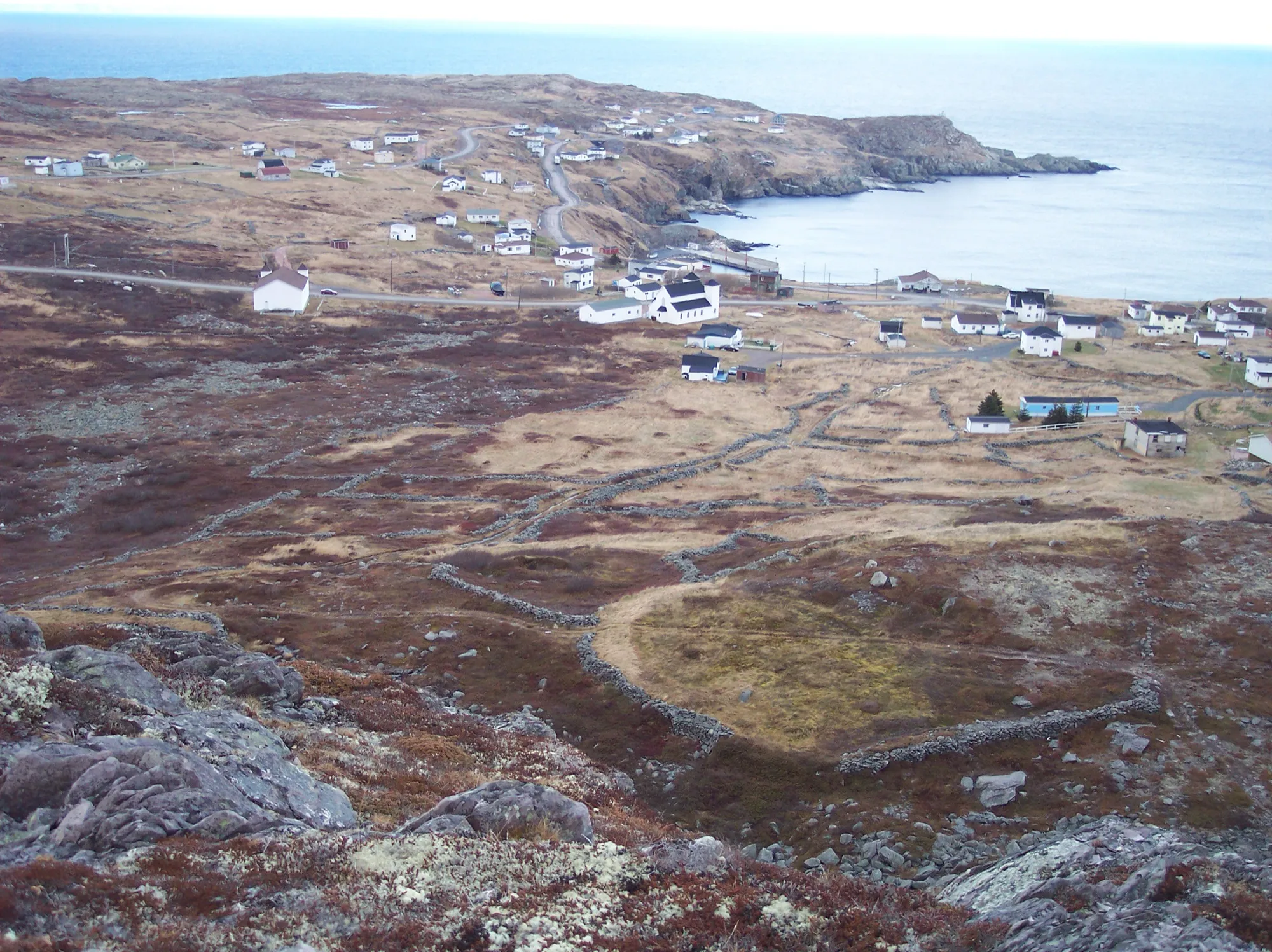
A National Historic Site of an unusual kind: hundreds of rock walls farmers built to keep roaming animals off their fields, dating back to 1790, per the province's tourism site. It sits at the peninsula's northwest tip.
Stopping here adds 29.7 km to the drive.
Directions →Show on map: Grates Cove ↑Other map apps
Apple · Google · Organic Maps · OsmAnd (both work offline, no tracking) · WazeStop 7: Winterton
Home of the Wooden Boat Museum of Newfoundland and Labrador, where the province's tourism site says you can learn how a traditional dory or punt is built.
Directions →Show on map: Winterton ↑Other map apps
Apple · Google · Organic Maps · OsmAnd (both work offline, no tracking) · WazeStop 8: Heart's Content Cable Station
In 1866 the first successful permanent transatlantic telegraph cable was landed at Heart’s Content, reducing the time to communicate across the Atlantic from weeks to minutes. The provincial historic site is an 1875 office building with a 1918 extension. It is open seasonally; the site’s page has the current dates.
Directions →Show on map: Heart's Content Cable Station ↑Other map apps
Apple · Google · Organic Maps · OsmAnd (both work offline, no tracking) · WazeStop 9: Shag Rock lookout
A lookout OpenStreetMap records beside Route 80 at Whiteway. The province's tourism site points to the jagged peaks of Shag Rock jutting out of the ocean here.
Directions →Show on map: Shag Rock lookout ↑Other map apps
Apple · Google · Organic Maps · OsmAnd (both work offline, no tracking) · Waze
Scan with your phone to open this page there. Then tap Keep for offline before you lose signal.
⛽ Fuel and gravel, road by road ▾
- Route 81 →Whole road: 1 fuel stations mapped, longest gap 27 km. Unpaved mapped: 18 km; 16% has no surface tag, so unknown.
- Route 1 →Whole road: 54 fuel stations mapped, longest gap 119 km. Unpaved mapped: none; 68% has no surface tag, so unknown.
- Route 71 →Whole road: 0 fuel stations mapped, longest gap 13 km. Unpaved mapped: 5 km; 61% has no surface tag, so unknown.
- Route 70 →Whole road: 13 fuel stations mapped, longest gap 48 km. Unpaved mapped: 0.3 km; 100% has no surface tag, so unknown.
- Route 60 →Whole road: 14 fuel stations mapped, longest gap 28 km. Unpaved mapped: none; 85% has no surface tag, so unknown.
- Route 75 →Whole road: 2 fuel stations mapped, longest gap 19 km. Unpaved mapped: none; 85% has no surface tag, so unknown.
- Route 80 →Whole road: 12 fuel stations mapped, longest gap 33 km. Unpaved mapped: none; 87% has no surface tag, so unknown.
Drive measured Sep 9, 2026, Whitbourne round by Brigus, Harbour Grace, Old Perlican and Heart's Content and back. Your maps app gives the time on the day. How we measure
Staying here? Days out ↓Keep for offline ↓Download GPX (offline, Garmin)
238.5 km. A loop the province names, starting at Whitbourne, where Routes 80 and 75 leave the Trans-Canada: up one side of the Avalon between Trinity Bay and Conception Bay, around the top at Old Perlican, and back down the other.
Check the seasons. The two main stops keep summer seasons.
Why people come. A cottage at Brigus where an Arctic captain came home between twenty expeditions, and an office at Heart’s Content where the Atlantic first got shorter.
When you get to Whitbourne
- Where to eat near Whitbourne → — 9 places the open map records, alphabetically, with addresses and phone numbers.
Sunrise and sunset at Whitbourne, by month
| Month (the 15th) | Sunrise | Sunset |
|---|---|---|
| January | 7:46 am | 4:38 pm |
| February | 7:10 am | 5:26 pm |
| March | 7:18 am | 7:08 pm |
| April | 6:16 am | 7:52 pm |
| May | 5:27 am | 8:32 pm |
| June | 5:06 am | 9:02 pm |
| July | 5:22 am | 8:57 pm |
| August | 5:59 am | 8:17 pm |
| September | 6:40 am | 7:17 pm |
| October | 7:21 am | 6:17 pm |
| November | 7:08 am | 4:29 pm |
| December | 7:44 am | 4:13 pm |
Worked out for the 15th of each month at this spot, in local time. The weather line at the top has today's.
Places to eat on the way
44 places to eat within 2 km of this drive, in the order you pass them.
The longest stretch with nothing mapped on it is 54 km — after Darkstar Coffee Roasters, until Robin's Donuts.
All 44, in the order you pass them — open the list
- Tim Hortonscafékm 4.1 · 962 m off the road
- Subwayfast foodkm 4.1 · 1003 m off the road
- A&Wfast foodkm 4.1 · 1072 m off the road
- Mary Brown'srestaurantkm 4.2 · 464 m off the road
- E&E Drive-Infast foodkm 33.2
- Skipper Ben's Dining Roomrestaurantkm 35.3 · 1720 m off the road
- The Convent B&Brestaurantkm 35.6
- The Convent Cafe and Barcafékm 35.6
- Vindicator Press Incorporatedcafékm 35.6
- North Street Cafecafékm 35.9
- Born and Bread Bakery and Caferestaurantkm 35.9
- The Quayrestaurantkm 36
- Silver Wood Innrestaurantkm 45.8
- Mary Brown'sfast foodkm 46.5 · 492 m off the road
- Greco Pizzafast foodkm 46.5 · 415 m off the road
- Country Delightrestaurantkm 46.5 · 440 m off the road
- McDonald'sfast foodkm 46.5 · 1487 m off the road
- Tim Hortonscafékm 46.5 · 1137 m off the road
- Jungle Jim's Eateryrestaurantkm 46.5 · 1653 m off the road
- A&Wfast foodkm 46.5 · 1394 m off the road
- KFCfast foodkm 46.5 · 1424 m off the road
- Greco Pizza / Sergio's Ice Creamfast foodkm 46.5 · 416 m off the road
- Country Delightrestaurantkm 46.5 · 440 m off the road
- Don's Restaurantrestaurantkm 71.5
- Dairy Queenfast foodkm 71.6
- Mary Brown'sfast foodkm 71.7 · 181 m off the road
- Tim Hortonscafékm 71.8
- Peters Pizzafast foodkm 72
- KFCfast foodkm 72
- Ches's Fish & Chipsfast foodkm 72.1
- Crooked Phil'scafékm 72.1
- McDonald'sfast foodkm 72.2
- Subwayfast foodkm 72.2
- The Stone Jugrestaurantkm 74.5 · 753 m off the road
- Cold Waterrestaurantkm 74.5 · 790 m off the road
- Studio Coffeecafékm 74.9 · 869 m off the road
- Darkstar Coffee Roasterscafékm 74.9 · 915 m off the road
- Robin's Donutsfast foodkm 128.9
- Jungle Jim'srestaurantkm 128.9
- I Sea Whalescafékm 167.7
- Dildo Brewing Company and Museumpubkm 218.2 · 522 m off the road
- Kountry Kravins & Kraftscafékm 218.2 · 485 m off the road
- The Barn Cafecafékm 223
- Blue Whale Lounge & Eateryrestaurantkm 224.3
Not ranked or complete, and nobody pays to be here. No opening hours: phone ahead. Open map data, swept 2026-09-12. How we measure · Add a missing place
Short drives from Whitbourne
Other map apps
Apple · Google · Organic Maps · OsmAnd (both work offline, no tracking) · WazeOr any of these: nearest first, measured by road from Whitbourne.
- Fitzgerald's Pond Provincial Parkstop27 km
A Provincial Park Reserve, not a provincial park with a campground.
Directions →Other map apps
Apple · Google · Organic Maps · OsmAnd (both work offline, no tracking) · Waze - Cupids Legacy Centrestop35 km
A museum at Cupids.
Directions →Other map apps
Apple · Google · Organic Maps · OsmAnd (both work offline, no tracking) · Waze - Clarke's Beachtown36 kmDirections →
Other map apps
Apple · Google · Organic Maps · OsmAnd (both work offline, no tracking) · Waze - Brigustown36 kmDirections →
Other map apps
Apple · Google · Organic Maps · OsmAnd (both work offline, no tracking) · Waze - Shag Rock lookoutstop36 km
A viewpoint OpenStreetMap records beside Route 80, close enough to the driven line that stopping costs nothing.
Directions →Other map apps
Apple · Google · Organic Maps · OsmAnd (both work offline, no tracking) · Waze - O'Reilly House Museumstop48 km
A house museum run by the Placentia Area Historical Society, a nonprofit and registered charity.
Directions →Other map apps
Apple · Google · Organic Maps · OsmAnd (both work offline, no tracking) · Waze - Castle Hill National Historic Sitestop48 km
A Parks Canada site on the hill above Placentia, early in the drive.
Directions →Other map apps
Apple · Google · Organic Maps · OsmAnd (both work offline, no tracking) · Waze - Salmonier Nature Parkstop48 km
Run by the province's wildlife division on the Salmonier Line.
Directions →Other map apps
Apple · Google · Organic Maps · OsmAnd (both work offline, no tracking) · Waze
More, up to 72 km (10)
- Placentiatown48 kmDirections →
Other map apps
Apple · Google · Organic Maps · OsmAnd (both work offline, no tracking) · Waze - Spirit of Harbour Gracestop50 km
A 1943 Douglas DC-3 that served in North Africa in the war and later flew freight between Stephenville and Goose Bay until 1988; Air Labrador's owner donated it to the town in 1993 as the Spirit of Harbour Grace, for the town's part in early transatlantic flight (explorenewfoundlandandlabrador.com).
Directions →Other map apps
Apple · Google · Organic Maps · OsmAnd (both work offline, no tracking) · Waze - Danny Cleary Lookoutstop51 km
A viewpoint OpenStreetMap records on the way into town.
Directions →Other map apps
Apple · Google · Organic Maps · OsmAnd (both work offline, no tracking) · Waze The 1884 Harbour Grace railway station, kept as a museum.
Directions →Other map apps
Apple · Google · Organic Maps · OsmAnd (both work offline, no tracking) · Waze- Harbour Gracetown54 kmDirections →
Other map apps
Apple · Google · Organic Maps · OsmAnd (both work offline, no tracking) · Waze - Butter Pot Provincial Parkstop55 km
The drive runs along this park's boundary, but the park reaches well inland.
Directions →Other map apps
Apple · Google · Organic Maps · OsmAnd (both work offline, no tracking) · Waze - Railway Station Museumstop58 km
Carbonear's station was built in 1917-18 by the Reid Newfoundland Company, replacing an earlier station destroyed by fire, and stayed the northern terminus of the Brigus Junction to Carbonear branch line until passenger trains ceased in 1984.
Directions →Other map apps
Apple · Google · Organic Maps · OsmAnd (both work offline, no tracking) · Waze - Heart's Contenttown65 kmDirections →
Other map apps
Apple · Google · Organic Maps · OsmAnd (both work offline, no tracking) · Waze - Gooseberry Cove Provincial Parkstop72 km
A provincial park on the Cape Shore, about halfway down and barely off the road.
Directions →Other map apps
Apple · Google · Organic Maps · OsmAnd (both work offline, no tracking) · Waze - Witless Baytown72 kmDirections →
Other map apps
Apple · Google · Organic Maps · OsmAnd (both work offline, no tracking) · Waze
Distances by road, measured on OpenStreetMap October 16, 2026, from where this route ends. Your maps app gives the time on the day. How we measure
Doing it electric
- Fast chargers on this drive
- Whitbourne km 0, Carbonear km 72
- Longest stretch without one
- 166 km
- Carbonear → Whitbourne, of 238 km driven
- Nearest fast charger to Whitbourne
- at Whitbourne
Coming in 2026 (NL Hydro, 2026-10-22): Whitbourne (km 4). Not counted until it opens.
NL Hydro fast chargers within 3 km of the drive. Check the app for one that's working. Exported 2026-10-22. How we measure
Paved or not, per the map
- Mapped as unpaved
- 6.7 km
- Hodgewater Line (4.97 km, 13.7 km from Whitbourne); Doctors Lane (0.05 km, 38.8 km from Whitbourne); Forest Pond Road (1.17 km, 44.7 km from Whitbourne)
- Mapped as paved
- 16%
- 30.6 km of 238.5 km driven
- No surface tag on the map
- 80%
- 152.5 km: surface not recorded
In a rental car: Hertz Canada’s terms say “use off paved roads or on roads which are not regularly maintained” voids the damage waiver. Check your own agreement. Hertz’s terms ↗. Source for these figures: OSRM driving profile, stored route query, with node annotations; OpenStreetMap surface tags via Overpass, checked 2026-09-09. Today's road conditions: 511.
Before you go
These change, so we link to the people who keep them up to date.
The historic sitesBoth keep summer seasons — the operators set the dates
Hawthorne Cottage is Parks Canada; the Heart’s Content Cable Station is a provincial historic site. Each sets its own calendar. Check both before you plan a day around them.
seethesites.ca →MooseYear round, worst between dusk and dawn
The province states the likelihood of injury in a moose collision is twice as high between dusk and dawn as in daytime. With 238 km of driving plus stops, most people finish this circuit in the evening, on roads between communities.
gov.nl.ca →Road conditionsYear round, matters most November–April
The peninsula is a long finger with the sea on both sides and one road up each. A closure has no detour; you turn around.
511nl.ca →
Questions
How far is the Baccalieu Coastal Drive?+
As a circuit from Whitbourne through Brigus, Harbour Grace, Old Perlican and Heart’s Content and back: 238.5 km of driving. Newfoundland and Labrador Tourism, which names the drive and gives Whitbourne as its start, gives about 310 km, a longer circuit taking in more of the peninsula. The tip, at Bay de Verde and Grates Cove, is a side trip here; its extra driving is measured with each stop.
Is this the Brigus loop?+
It is the drive Brigus is on; the province does not name a separate Brigus loop. Brigus sits early on this circuit, and Hawthorne Cottage is on the driven line. The other Conception Bay drive the province names, the Admiral’s Coast, is Route 60 only and does not reach Brigus.
Which airport is this drive near?+
From St. John’s airport it is 93 km to Whitbourne; off the Argentia ferry, 51 km. The circuit is the same whichever way you arrive.
No recorded track yet.Drove it? Send yours →
Put this map on your site
Run a place to stay, a tour or a town page on this drive? Add this map to your site. It shows your guests the drive and its distance. It is free, needs no account, and we keep the figures current.
<iframe src="https://fromtheairport.xyz/embed/baccalieu-coastal-drive"
  width="100%" height="420" style="border:0" loading="lazy"
title="Driving route: Baccalieu Coastal Drive, a loop from Whitbourne"></iframe>?lat=&lon=&label= to the URL to pin your own property on the map.Every distance and coordinate on this page was checked against its source on September 9, 2026. Origin: OpenStreetMap node/10538282182. Destination: OpenStreetMap node/10538282182.