Gander International Airport (YQX) → Harbour Grace
Gander Airport (YQX) to Harbour Grace
The drive from every airport and ferry ↓
- Distance
- 298.1 km
- Drive time
- In your maps app ↗
Use another map app
Apple Maps · Google Maps · Organic Maps · OsmAnd (both work offline, no tracking) · Waze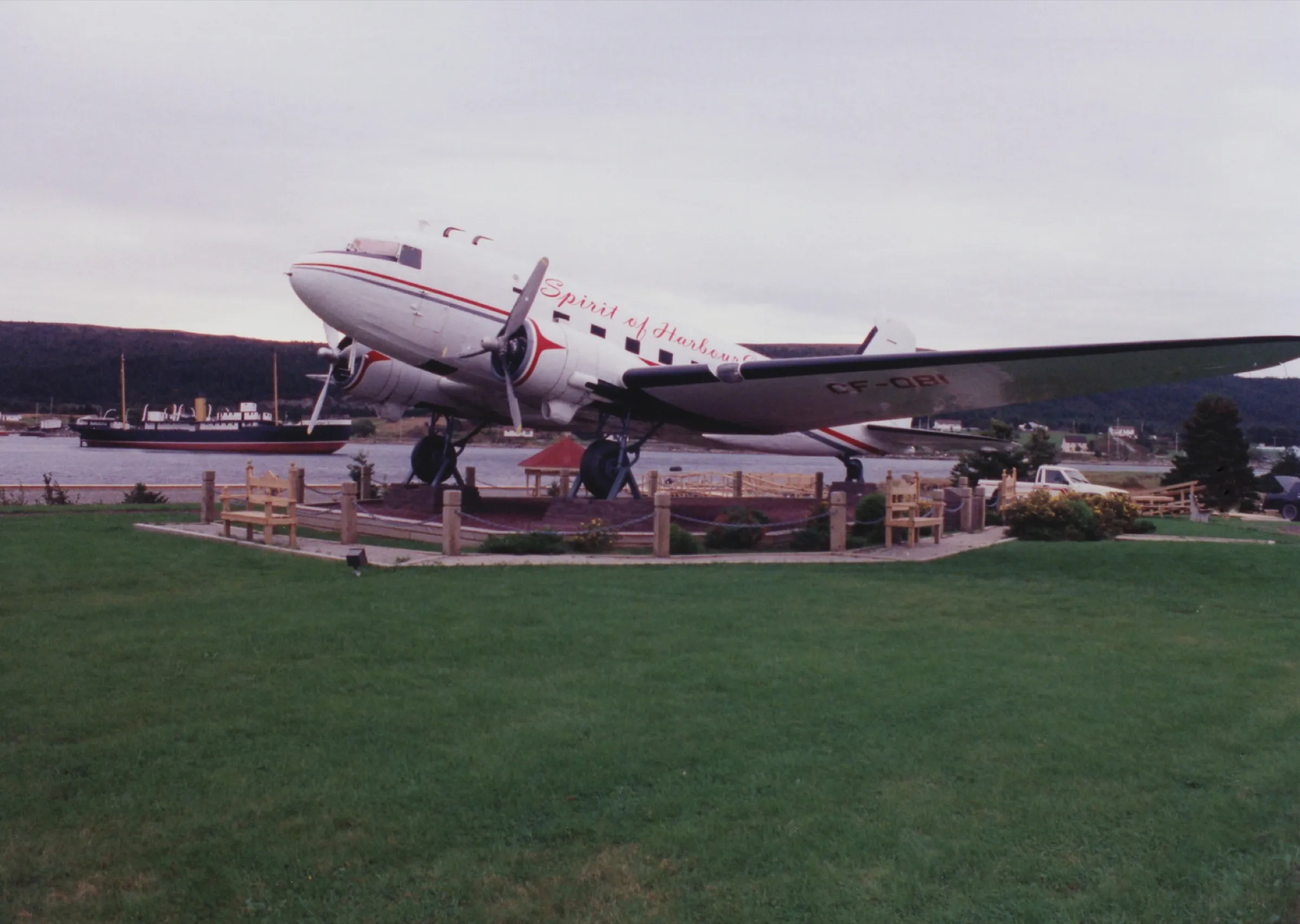

Faded lines are other drives from Gander International into this area: Brigus (280 km), Clarke's Beach (280 km), Heart's Content (308 km), Portugal Cove ferry terminal (338 km), St. John's (335 km), Signal Hill (Cabot Tower) (338 km), Salmonier Nature Park (292 km), Cape Spear (346 km). Each splits off where its line leaves this one.
Stop 1: Silent Witnesses MemorialDetour
A memorial on Route 1 outside Gander, unveiled in 1990 for the lives lost in the Arrow Air crash of 12 December 1985. An American soldier stands atop a rock holding the hands of a civilian boy and girl, each child carrying an olive branch for the Screaming Eagles' peacekeeping mission in the Sinai; they were going home for Christmas. The trio look toward Fort Campbell, Kentucky, where a similar statue looks back.
Stopping here adds 2.4 km to the drive.
Directions →Show on map: Silent Witnesses Memorial ↑Other map apps
Apple · Google · Organic Maps · OsmAnd (both work offline, no tracking) · WazeStop 2: Square Pond
A pond-side stop beside the Trans-Canada. OpenStreetMap still uses its old provincial-park name; the province no longer lists it. A place to stretch your legs.
Stopping here adds 0.7 km to the drive.
Directions →Show on map: Square Pond ↑Other map apps
Apple · Google · Organic Maps · OsmAnd (both work offline, no tracking) · WazeStop 3: Joey's Lookout
A mapped viewpoint on the Trans-Canada east of Gander, effectively on the road. OpenStreetMap records only the name and that it is a viewpoint. It is easy to miss at highway speed.
Stopping here adds 0.1 km to the drive.
Directions →Show on map: Joey's Lookout ↑Other map apps
Apple · Google · Organic Maps · OsmAnd (both work offline, no tracking) · WazeStop 4: Sandy PondDetour
One of the park's officially designated observing sites under its Dark-Sky Preserve status: the Royal Astronomical Society of Canada designated Terra Nova on 26 February 2018, and Parks Canada's own night-sky page calls Sandy Pond the darkest skies in the park. RASC notes the designated sites have paved parking with a walk to the observing spot. The pond also has a beach and a trail for daytime. After dark, the drive back to the highway is moose country.
Stopping here adds 4.8 km to the drive.
Directions →Show on map: Sandy Pond ↑Other map apps
Apple · Google · Organic Maps · OsmAnd (both work offline, no tracking) · WazeStop 5: Spirit of Harbour Grace
A 1943 Douglas DC-3 that served in North Africa in the war and later flew freight between Stephenville and Goose Bay until 1988; Air Labrador's owner donated it to the town in 1993 as the Spirit of Harbour Grace, for the town's part in early transatlantic flight (explorenewfoundlandandlabrador.com). The tourism board lists the town's old airfield, a separate site in Harbour Grace, and says locals built that strip in 1927, that it hosted transatlantic flight attempts through the interwar period, and that Amelia Earhart left it on her successful solo flight in 1932.
Stopping here adds 0.2 km to the drive.
Directions →Show on map: Spirit of Harbour Grace ↑Other map apps
Apple · Google · Organic Maps · OsmAnd (both work offline, no tracking) · WazeStop 6: Gordon G. Pike Railway Heritage Museum
Built in 1884, this was the Harbour Grace Railway Station, terminus of the first railroad constructed in Newfoundland. The tourism board's listing calls it the oldest railway station built outside St. John's and the oldest still standing in the province, and says the building has been restored in vintage colours. OpenStreetMap records it as a museum today.
Stopping here adds 0.9 km to the drive.
Directions →Show on map: Gordon G. Pike Railway Heritage Museum ↑Other map apps
Apple · Google · Organic Maps · OsmAnd (both work offline, no tracking) · Waze
Scan with your phone to open this page there. Then tap Keep for offline before you lose signal.
⛽ Fuel and gravel, road by road ▾
- Route 330 →Whole road: 8 fuel stations mapped, longest gap 42 km. Unpaved mapped: none; 70% has no surface tag, so unknown.
- Route 1 →Whole road: 54 fuel stations mapped, longest gap 119 km. Unpaved mapped: none; 68% has no surface tag, so unknown.
- Route 71 →Whole road: 0 fuel stations mapped, longest gap 13 km. Unpaved mapped: 5 km; 61% has no surface tag, so unknown.
- Route 75 →Whole road: 2 fuel stations mapped, longest gap 19 km. Unpaved mapped: none; 85% has no surface tag, so unknown.
- Route 70 →Whole road: 13 fuel stations mapped, longest gap 48 km. Unpaved mapped: 0.3 km; 100% has no surface tag, so unknown.
Drive measured Oct 19, 2026, Gander International Airport (YQX) to Harbour Grace. Your maps app gives the time on the day. How we measure
Add to a trip →Staying here? Days out ↓Keep for offline ↓Airport info: Gander International Airport →
298.1 km. From Gander airport to Harbour Grace, on Routes 330, 1, 71, 75 and 70.
When you get to Harbour Grace
- Staying in Harbour Grace? → — the start page: short drives from town, food, and a planner that starts here.
- Where to eat near Harbour Grace → — 34 places the open map records, alphabetically, with addresses and phone numbers.
- Danny Cleary Harbour Grace Community Centre → · S. W. Moores Memorial Stadium → — the venues here, with what you can reach and be back from between games.
Sunrise and sunset at Harbour Grace, by month
| Month (the 15th) | Sunrise | Sunset |
|---|---|---|
| January | 7:46 am | 4:36 pm |
| February | 7:09 am | 5:24 pm |
| March | 7:17 am | 7:07 pm |
| April | 6:14 am | 7:51 pm |
| May | 5:25 am | 8:32 pm |
| June | 5:03 am | 9:02 pm |
| July | 5:19 am | 8:57 pm |
| August | 5:57 am | 8:17 pm |
| September | 6:39 am | 7:16 pm |
| October | 7:20 am | 6:16 pm |
| November | 7:08 am | 4:27 pm |
| December | 7:44 am | 4:11 pm |
Worked out for the 15th of each month at this spot, in local time. The weather line at the top has today's.
Places to eat on the way
28 near the start: where to eat in Gander →
39 places to eat within 2 km of this drive, in the order you pass them.
The longest stretch with nothing mapped on it is 47.3 km — after Meghan's Restaurant, until A&W.
Every one of them, in the order you pass them
- Copper Kettle Restaurantrestaurantkm 31.9
- Family Pizzarestaurantkm 38.7 · 1870 m off the road
- Mary Brown'srestaurantkm 68.3
- Happy Adventure Cafecafékm 76.4 · 1229 m off the road
- Snack shack.fast foodkm 115 · 624 m off the road
- Robin's Donutsfast foodkm 144.1 · 1142 m off the road
- A&Wfast foodkm 144.2 · 585 m off the road
- A&Wfast foodkm 144.2 · 585 m off the road
- Rod's Restaurantrestaurantkm 144.3 · 508 m off the road
- Don Cherry's Sports Bar & Grillrestaurantkm 144.3 · 200 m off the road
- KFCfast foodkm 144.5 · 773 m off the road
- Jungle Jim'srestaurantkm 144.5 · 488 m off the road
- Jungle Jim'srestaurantkm 144.5 · 488 m off the road
- Tim Hortonscafékm 144.6 · 593 m off the road
- McDonald'sfast foodkm 144.6 · 539 m off the road
- Mary Brown'sfast foodkm 144.6 · 676 m off the road
- Pizza Delightrestaurantkm 146.1 · 1264 m off the road
- Brownings Pubpubkm 146.2 · 1212 m off the road
- Flannigans Pubpubkm 146.2 · 1229 m off the road
- Tim Hortonscafékm 147.9
- Tim Hortonscafékm 147.9
- Breen'srestaurantkm 174.4
- Robin's Donutscafékm 174.7
- Meghan's Restaurantrestaurantkm 198.9
- A&Wfast foodkm 246.2
- Tim Hortonscafékm 246.3
- Subwayfast foodkm 246.3
- Mary Brown'srestaurantkm 246.9
- Silver Wood Innrestaurantkm 277.1 · 1549 m off the road
- Mary Brown'sfast foodkm 278.9 · 1627 m off the road
- Greco Pizzafast foodkm 278.9 · 1545 m off the road
- Country Delightrestaurantkm 278.9 · 1552 m off the road
- Greco Pizza / Sergio's Ice Creamfast foodkm 278.9 · 1538 m off the road
- Country Delightrestaurantkm 278.9 · 1553 m off the road
- Tim Hortonscafékm 279.1 · 1682 m off the road
- A&Wfast foodkm 279.1 · 1890 m off the road
- KFCfast foodkm 279.1 · 1906 m off the road
- McDonald'sfast foodkm 279.2 · 1878 m off the road
- Jungle Jim's Eateryrestaurantkm 279.2 · 1899 m off the road
Not ranked or complete, and nobody pays to be here. No opening hours: phone ahead. Open map data, swept 2026-10-18. How we measure · Add a missing place
New place to eat, or one that's missing? This list comes from OpenStreetMap, so nobody can pay to be on it. Add it to the map yourself (about twenty minutes on a phone), or email us the details and we'll put it on the map.
Short drives from Harbour Grace
Other map apps
Apple · Google · Organic Maps · OsmAnd (both work offline, no tracking) · WazeOr any of these: nearest first, measured by road from Harbour Grace.
- Danny Cleary Lookoutstop6.3 km
A viewpoint OpenStreetMap records on the way into town.
Directions →Other map apps
Apple · Google · Organic Maps · OsmAnd (both work offline, no tracking) · Waze - Railway Station Museumstop6.6 km
Carbonear's station was built in 1917-18 by the Reid Newfoundland Company, replacing an earlier station destroyed by fire, and stayed the northern terminus of the Brigus Junction to Carbonear branch line until passenger trains ceased in 1984.
Directions →Other map apps
Apple · Google · Organic Maps · OsmAnd (both work offline, no tracking) · Waze - Salmon Cove Sandsstop16 km
The province's tourism site points to Salmon Cove Sands here: a heart-shaped beach of fine sand under tall cliffs, with a 2 km hiking trail.
Directions →Other map apps
Apple · Google · Organic Maps · OsmAnd (both work offline, no tracking) · Waze - Clarke's Beachtown25 kmDirections →
Other map apps
Apple · Google · Organic Maps · OsmAnd (both work offline, no tracking) · Waze - Cupids Legacy Centrestop30 km
A museum at Cupids.
Directions →Other map apps
Apple · Google · Organic Maps · OsmAnd (both work offline, no tracking) · Waze - Brigustown31 kmDirections →
Other map apps
Apple · Google · Organic Maps · OsmAnd (both work offline, no tracking) · Waze - Butter Pot Provincial Parkstop70 km
The drive runs along this park's boundary, but the park reaches well inland.
Directions →Other map apps
Apple · Google · Organic Maps · OsmAnd (both work offline, no tracking) · Waze - Seal Covestop70 km
The western end of Conception Bay South, which the province's tourism site describes as a string of shoreline communities from Seal Cove to Topsail.
Directions →Other map apps
Apple · Google · Organic Maps · OsmAnd (both work offline, no tracking) · Waze
More, up to 85 km (5)
- Kelligrewsstop74 km
The community of the song Kelligrews Soirée, which also names the town's yearly folk festival, per the province's tourism site.
Directions →Other map apps
Apple · Google · Organic Maps · OsmAnd (both work offline, no tracking) · Waze - Long Pondstop79 km
Where the province's tourism site sends divers first.
Directions →Other map apps
Apple · Google · Organic Maps · OsmAnd (both work offline, no tracking) · Waze - Bellevue Beachstop81 km
A sandy beach on Route 201, in what the province's tourism site calls a popular summer cottage area.
Directions →Other map apps
Apple · Google · Organic Maps · OsmAnd (both work offline, no tracking) · Waze - Manuels River Interpretation Centrestop81 km
A fossil bed and walking trail on Manuels River, with guided walks back to when trilobites ruled the seas.
Directions →Other map apps
Apple · Google · Organic Maps · OsmAnd (both work offline, no tracking) · Waze - Chance Cove Coastal Trailstop85 km
A trail through the forest to the far end of Chance Cove Beach, then uphill along the coast to hidden sandy beaches, lookouts and sea caves, per the province's tourism site.
Directions →Other map apps
Apple · Google · Organic Maps · OsmAnd (both work offline, no tracking) · Waze
Distances by road, measured on OpenStreetMap October 16, 2026, from where this route ends. Your maps app gives the time on the day. How we measure
Doing it electric
- Fast chargers on this drive
- Gander km 3, Glowertown km 68, Port Blandford km 116, Goobies km 175
- Longest stretch without one
- 123 km
- Goobies → Harbour Grace, of 298 km driven
- Nearest fast charger to Harbour Grace
- 5.1 km
- by road, at Carbonear
No fast charger at Harbour Grace. From Goobies it is 123 km there and the same back: plan on about 246 km on one charge, more in cold weather or with the heat on. Or charge at Carbonear, 5.1 km from Harbour Grace by road, off this drive's own road.
Coming in 2026 (NL Hydro, 2026-10-22): Gander (km 2) and Clarenville (km 148) and Whitbourne (km 247). Not counted until it opens.
NL Hydro fast chargers within 3 km of the drive. Check the app for one that's working. Exported 2026-10-22. How we measure
Paved or not, per the map
- Mapped as unpaved
- 5 km
- Doctors Lane (0.05 km, 0 km from Harbour Grace); Hodgewater Line (4.97 km, 28.2 km from Harbour Grace)
- Mapped as paved
- 26%
- 70.9 km of 298.1 km driven
- No surface tag on the map
- 72%
- 193.5 km: surface not recorded
In a rental car: Hertz Canada’s terms say “use off paved roads or on roads which are not regularly maintained” voids the damage waiver. Check your own agreement. Hertz’s terms ↗. Source for these figures: OSRM driving profile, stored route query, with node annotations; OpenStreetMap surface tags via Overpass, checked 2026-10-19. Today's road conditions: 511.
Before you go
These change, so we link to the people who keep them up to date.
MooseYear round, worst between dusk and dawn
The province says the likelihood of injury in a moose collision is twice as high between dusk and dawn as in daytime. This is 298.1 km, much of it unlit two-lane highway; plan the drive for daylight where you can.
gov.nl.ca →Road conditionsYear round, matters most November–April
Conditions change fast on this coast. Check before you set off.
511nl.ca →
Renting a car? Book the car when you book the flight.
Summer rentals sell out, says NL Tourism, and in June 2026 BNN Bloomberg reported St. John's airport agencies booked for nearly all of summer.
Both checked October 7, 2026.
Rental counters at Gander, with numbers →Arriving without a car
Not renting? Here's who Gander International Airport Authority lists at the terminal.
No rideshare here.
The Airport Authority's transport page lists no rideshare service (checked 2026-09-15).
Taxi
Busy Bee Cabs, which the Airport Authority says runs a 24-hour service available curbside in the Domestic Arrivals area.
Coach
DRL Coachlines runs the island's one scheduled coach, once a day each way, between St. John's and the Marine Atlantic terminal at Port aux Basques. It stops at Gander Airport itself (the restaurant), and at Lewisporte, Grand Falls-Windsor, Deer Lake and Corner Brook among others. It reaches no island and no national park. Tickets are bought on the bus, cash only. The Airport Authority says a wheelchair-accessible bus needs 48 hours' notice. Times and fares are DRL's: drl-lr.com.
Limousine
Nobel Limousines, listed by the Airport Authority.
Avis, Budget, National and Enterprise are listed at the airport. The Authority says accessible vehicles with wheelchair accommodation or hand controls are limited and need 48 hours' notice.
Source: Gander International Airport Authority,2026-09-15. Check there for fares and times.
Questions
How far is Harbour Grace from Gander airport?+
298.1 km from the terminal to Harbour Grace.
What route do I take?+
Routes 330, 1, 71, 75 and 70. Your maps app has the turns.
Do I need a car?+
Plan on one. Buses between these towns are few, and the drive is the way most people make it.
No recorded track yet.Drove it? Send yours →
Put this map on your site
Run a place to stay, a tour or a town page on this drive? Add this map to your site. It shows your guests the drive and its distance. It is free, needs no account, and we keep the figures current.
<iframe src="https://fromtheairport.xyz/embed/yqx-harbour-grace"
  width="100%" height="420" style="border:0" loading="lazy"
title="Driving route: Gander International Airport (YQX) to Harbour Grace"></iframe>?lat=&lon=&label= to the URL to pin your own property on the map.Every distance and coordinate on this page was checked against its source on October 19, 2026. Origin: OpenStreetMap way/154350645 — Terminal. Destination: OpenStreetMap node/475349146 — Harbour Grace.