A loop from Gambo
Kittiwake Coast: Road to the Shore
Getting to the start from every airport and ferry ↓
- Distance
- 307.4 km
- Drive time
- In your maps app ↗
Google Maps is the one app that takes a loop's stops in order from a link. In another app, drive it stop by stop from the list below.

Stop 1: Dover Fault Interpretation CentreDetour
The centre for the Dover Fault, which the province's tourism site describes as a major break in the Earth's crust where the North American and European continents collided. The trail beside it climbs to a lookout with interpretation panels.
Stopping here adds 3.7 km to the drive.
Directions →Show on map: Dover Fault Interpretation Centre ↑Other map apps
Apple · Google · Organic Maps · OsmAnd (both work offline, no tracking) · WazeStop 2: Greenspond Courthouse
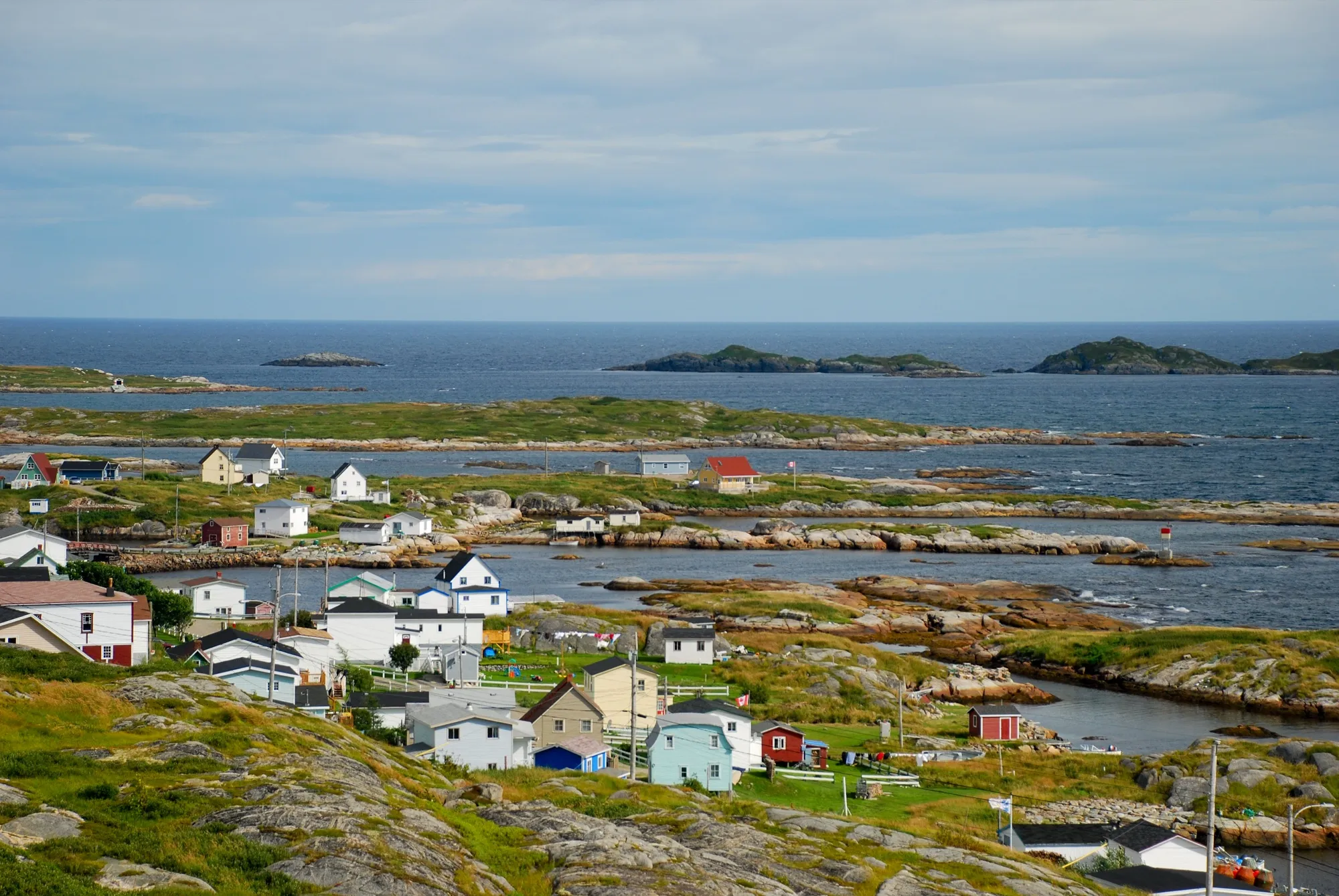
Greenspond's 19th-century courthouse, kept as a heritage site. The province's tourism site calls Greenspond one of the oldest continuously inhabited outports in the province, with a European presence from the 1690s.
Directions →Show on map: Greenspond Courthouse ↑Other map apps
Apple · Google · Organic Maps · OsmAnd (both work offline, no tracking) · WazeStop 3: NewtownDetour
The province's tourism site calls Newtown the Venice of Newfoundland, built across small islands, and points to the Barbour House: a Queen Anne-style merchant's mansion from 1904 with its original furnishings, beside the town's heritage village.
Stopping here adds 4.8 km to the drive.
Directions →Show on map: Newtown ↑Other map apps
Apple · Google · Organic Maps · OsmAnd (both work offline, no tracking) · WazeStop 4: Cape FreelsDetour
A beach on a coast BirdLife International has designated an Important Bird Area for nesting seabirds, among them common eiders, murres, razorbills and Arctic terns, per the province's tourism site.
Stopping here adds 9.8 km to the drive.
Directions →Show on map: Cape Freels ↑Other map apps
Apple · Google · Organic Maps · OsmAnd (both work offline, no tracking) · WazeStop 5: Windmill Bight Park Reserve
Three kilometres from Lumsden off Route 330. It protects a long sand and beachrock bar between the sea and a calm barachois, and habitat for migrating shorebirds. The province classes it as a park reserve, and reserves have no day-use or camping facilities. Many were provincial parks whose campground was leased out. Come for the beach and bring what you need.
Stopping here adds 1.3 km to the drive.
Directions →Show on map: Windmill Bight Park Reserve ↑Other map apps
Apple · Google · Organic Maps · OsmAnd (both work offline, no tracking) · WazeStop 6: Lumsden Beach
The beach the province's tourism site calls the most popular on the Kittiwake Coast. The Wonder Shore trail follows the coast from here over dunes and cliffs.
Stopping here adds 1.5 km to the drive.
Directions →Show on map: Lumsden Beach ↑Other map apps
Apple · Google · Organic Maps · OsmAnd (both work offline, no tracking) · WazeStop 7: Deadman's Bay beach
A beach of fine beige sand a few minutes from Lumsden, per the province's tourism site.
Stopping here adds 0.3 km to the drive.
Directions →Show on map: Deadman's Bay beach ↑Other map apps
Apple · Google · Organic Maps · OsmAnd (both work offline, no tracking) · WazeStop 8: Musgrave Harbour
A beach town with the Fishermen's Museum, in a building Sir William Coaker put up in 1910, as the province's tourism site tells it: artifacts from the fishery inside, a painted mural outside.
Directions →Show on map: Musgrave Harbour ↑Other map apps
Apple · Google · Organic Maps · OsmAnd (both work offline, no tracking) · WazeStop 9: Carmanville Wetlands Interpretation Centre
Carmanville's wetlands centre beside Route 330. The province's tourism site gives it four kilometres of walking trails for songbirds and waterfowl.
Directions →Show on map: Carmanville Wetlands Interpretation Centre ↑Other map apps
Apple · Google · Organic Maps · OsmAnd (both work offline, no tracking) · WazeStop 10: Joey's Lookout
A lookout over Gambo and the Gambo River, with a giant sculpture of Joey Smallwood's head, per the province's tourism site. Gambo is where he was born.
Directions →Show on map: Joey's Lookout ↑Other map apps
Apple · Google · Organic Maps · OsmAnd (both work offline, no tracking) · Waze
Scan with your phone to open this page there. Then tap Keep for offline before you lose signal.
⛽ Fuel and gravel, road by road ▾
- Route 320 →Whole road: 6 fuel stations mapped, longest gap 39 km. Unpaved mapped: none; 72% has no surface tag, so unknown.
- Route 330 →Whole road: 8 fuel stations mapped, longest gap 42 km. Unpaved mapped: none; 70% has no surface tag, so unknown.
- Route 1 →Whole road: 54 fuel stations mapped, longest gap 119 km. Unpaved mapped: none; 68% has no surface tag, so unknown.
Drive measured Oct 10, 2026, Gambo round by Greenspond, New-Wes-Valley, Musgrave Harbour and Carmanville, back by Gander. Your maps app gives the time on the day. How we measure
Staying here? Days out ↓Keep for offline ↓Download GPX (offline, Garmin)
307.4 km, all the way round. The province’s Kittiwake Coast drive along the Atlantic shore is a circle, not a there and back: Route 320 from Gambo out to Greenspond, on its island at the end of a causeway, then Route 330 along the shore past Newtown and Lumsden to Musgrave Harbour, and home west through Carmanville to Gander. Only the spur out to Greenspond is driven twice.
A full day, not an afternoon. The beach at Windmill Bight makes it longer.
When you get to Gambo
- Where to eat near Gambo → — 7 places the open map records, alphabetically, with addresses and phone numbers.
Sunrise and sunset at Gambo, by month
| Month (the 15th) | Sunrise | Sunset |
|---|---|---|
| January | 7:54 am | 4:36 pm |
| February | 7:15 am | 5:26 pm |
| March | 7:21 am | 7:11 pm |
| April | 6:16 am | 7:56 pm |
| May | 5:25 am | 8:40 pm |
| June | 5:02 am | 9:11 pm |
| July | 5:19 am | 9:06 pm |
| August | 5:59 am | 8:23 pm |
| September | 6:42 am | 7:21 pm |
| October | 7:25 am | 6:18 pm |
| November | 7:15 am | 4:28 pm |
| December | 7:53 am | 4:10 pm |
Worked out for the 15th of each month at this spot, in local time. The weather line at the top has today's.
Places to eat on the way
1 near Gambo: where to eat near Gambo →
37 places to eat within 2 km of this drive, in the order you pass them.
The longest stretch with nothing mapped on it is 98 km — after Rocky Ridge Diner, until Little Caesars.
Every one of them, in the order you pass them
- Washed Ashorecafékm 35.3
- Aunt Hannah's Cafe and Gallerycafékm 39.8
- Sunset Grillrestaurantkm 40
- Silver Fox Loungecafékm 40.6
- Ida's placecafékm 73.5 · 335 m off the road
- Dykes Marinefast foodkm 74.1 · 307 m off the road
- Amy's Placerestaurantkm 111.1
- Rocky Ridge Dinerrestaurantkm 159.9
- Little Caesarsfast foodkm 257.9
- Wing 'n Itrestaurantkm 258.1 · 312 m off the road
- Rosie's Restaurant & Bakeryrestaurantkm 258.1 · 779 m off the road
- The Newfoundland Tea Co. Restaurant & Shoprestaurantkm 258.2 · 627 m off the road
- Tim Hortonscafékm 258.3
- Jumping Bean Coffee Companycafékm 258.4 · 583 m off the road
- Lilly's Landing Family Restaurantrestaurantkm 258.4 · 547 m off the road
- Pizza Housefast foodkm 258.4 · 595 m off the road
- East Ocean Restaurantfast foodkm 258.4 · 598 m off the road
- KFCfast foodkm 258.5 · 204 m off the road
- Ches's Fish & Chipsrestaurantkm 258.5 · 483 m off the road
- The Shawarma Stationrestaurantkm 258.5 · 250 m off the road
- Louis Geesfast foodkm 258.5 · 712 m off the road
- Jade Garden Restaurantrestaurantkm 258.5 · 640 m off the road
- New Highlight Restaurantrestaurantkm 258.5 · 620 m off the road
- Grecofast foodkm 258.5 · 632 m off the road
- Tim Hortonscafékm 258.5 · 227 m off the road
- Subwayfast foodkm 258.7
- McDonald'sfast foodkm 258.7
- A&Wfast foodkm 258.7 · 1553 m off the road
- Subwayfast foodkm 258.8 · 1526 m off the road
- Mystic Roomrestaurantkm 258.8 · 417 m off the road
- Pizza Delightrestaurantkm 258.9 · 276 m off the road
- Mary Brown'sfast foodkm 258.9 · 1377 m off the road
- Swiss Chaletrestaurantkm 258.9
- Robin's Donutsfast foodkm 258.9
- Tim Hortonscafékm 259.1 · 1265 m off the road
- DQ Grill & Chillfast foodkm 259.2 · 1054 m off the road
- Copper Kettle Restaurantrestaurantkm 288.6
Not ranked or complete, and nobody pays to be here. No opening hours: phone ahead. Open map data, swept 2026-10-11. How we measure · Add a missing place
Short drives from Gambo
Other map apps
Apple · Google · Organic Maps · OsmAnd (both work offline, no tracking) · WazeOr any of these: nearest first, measured by road from Gambo.
- Joey's Lookoutstop8.1 km
The viewpoint above Gambo.
Directions →Other map apps
Apple · Google · Organic Maps · OsmAnd (both work offline, no tracking) · Waze - Square Pondstop17 km
A campground a little under halfway along, right on the Trans-Canada.
Directions →Other map apps
Apple · Google · Organic Maps · OsmAnd (both work offline, no tracking) · Waze - Dover Fault Interpretation Centrestop22 km
In town and right on the route: the interpretation centre for the fault, with the Dover Fault Trail beside it climbing to the lookout.
Directions →Other map apps
Apple · Google · Organic Maps · OsmAnd (both work offline, no tracking) · Waze - Dovertown23 kmDirections →
Other map apps
Apple · Google · Organic Maps · OsmAnd (both work offline, no tracking) · Waze - Louil Hill Trailtrail · 3.7 km loop · easy34 kmDirections →
Other map apps
Apple · Google · Organic Maps · OsmAnd (both work offline, no tracking) · Waze - Mill Cove Lookout Trailtrail · 1.6 km out and back · easy35 kmDirections →
Other map apps
Apple · Google · Organic Maps · OsmAnd (both work offline, no tracking) · Waze - Malady Head Trailtrail · 3.8 km out and back · easy38 kmDirections →
Other map apps
Apple · Google · Organic Maps · OsmAnd (both work offline, no tracking) · Waze - Coastal Trail (Terra Nova)trail · 8.4 km out and back · moderate41 kmDirections →
Other map apps
Apple · Google · Organic Maps · OsmAnd (both work offline, no tracking) · Waze
More, up to 52 km (10)
- Goowiddy Pathtrail · 8 km loop · moderate41 kmDirections →
Other map apps
Apple · Google · Organic Maps · OsmAnd (both work offline, no tracking) · Waze - Mount Stamford Look-off Trailtrail · 2.2 km out and back · easy41 kmDirections →
Other map apps
Apple · Google · Organic Maps · OsmAnd (both work offline, no tracking) · Waze - Silent Witnesses Memorialstop43 km
A memorial on Route 1 outside Gander.
Directions →Other map apps
Apple · Google · Organic Maps · OsmAnd (both work offline, no tracking) · Waze - Edgar Baird Lakeside Trailtrail · 4.2 km walk · easy44 kmDirections →
Other map apps
Apple · Google · Organic Maps · OsmAnd (both work offline, no tracking) · Waze - Outport Trailtrail · 35 km out and back · strenuous46 kmDirections →
Other map apps
Apple · Google · Organic Maps · OsmAnd (both work offline, no tracking) · Waze - North Atlantic Aviation Museumstop48 km
On the Trans-Canada at 135, per the museum's own page: Gander's story from 1935 to 2001, the Second World War, the transatlantic crossroads years and 9/11.
Directions →Other map apps
Apple · Google · Organic Maps · OsmAnd (both work offline, no tracking) · Waze - Gander Golf Clubstop49 km
The closest golf course to the Gander terminal, right off this road.
Directions →Other map apps
Apple · Google · Organic Maps · OsmAnd (both work offline, no tracking) · Waze - Gandertown49 kmDirections →
Other map apps
Apple · Google · Organic Maps · OsmAnd (both work offline, no tracking) · Waze - Gander Old Town Sitestop50 km
The mapped historic ruins of the original Gander townsite, close to the terminal.
Directions →Other map apps
Apple · Google · Organic Maps · OsmAnd (both work offline, no tracking) · Waze - Airport Nordic Ski Clubstop52 km
A cross-country ski club named after the airport you just left.
Directions →Other map apps
Apple · Google · Organic Maps · OsmAnd (both work offline, no tracking) · Waze
Distances by road, measured on OpenStreetMap October 16, 2026, from where this route ends. Your maps app gives the time on the day. How we measure
Doing it electric
- Fast chargers on this drive
- Gander km 260
- Longest stretch without one
- 260 km
- the start → Gander, of 307 km driven
- Nearest fast charger to Gambo
- 31.9 km
- by road, at Glowertown
Coming in 2026 (NL Hydro, 2026-10-22): Gander (km 260). Not counted until it opens.
NL Hydro fast chargers within 3 km of the drive. Check the app for one that's working. Exported 2026-10-22. How we measure
Paved or not, per the map
- Mapped as unpaved
- 0.8 km
- Cemetery Road (0.3 km, 55.6 km from Gambo); Cemetary Road (0.09 km, 55.6 km from Gambo); Burt's Drive (0.42 km, 75.1 km from Gambo)
- Mapped as paved
- 26%
- 66.4 km of 307.4 km driven
- No surface tag on the map
- 74%
- 189.6 km: surface not recorded
In a rental car: Hertz Canada’s terms say “use off paved roads or on roads which are not regularly maintained” voids the damage waiver. Check your own agreement. Hertz’s terms ↗. Source for these figures: OSRM driving profile, stored route query, with node annotations; OpenStreetMap surface tags via Overpass, checked 2026-10-10. Today's road conditions: 511.
Before you go
These change, so we link to the people who keep them up to date.
ShorebirdsMigration; the timing moves
Windmill Bight is protected in part as habitat for migrating shorebirds, which use the barachois behind the bar. This page cannot give a date; ask local birders.
gov.nl.ca →MooseYear round, worst between dusk and dawn
The province states the likelihood of injury in a moose collision is twice as high between dusk and dawn as in daytime. 307 km of driving is a full day, and Routes 320 and 330 have long unlit stretches between communities.
gov.nl.ca →Road conditionsYear round, matters most November–April
This shore gets the weather off the open Atlantic first. Check before you commit to a 307 km circuit with a causeway on it.
511nl.ca →
Questions
How far is the Road to the Shore?+
Measured here as a full circle from Gambo: Route 320 out to Greenspond and New-Wes-Valley, Route 330 along the shore past Newtown and Lumsden to Musgrave Harbour, then west through Carmanville and Gander Bay to Gander, and the Trans-Canada back to Gambo. 307.4 km of driving. Newfoundland and Labrador Tourism, which names the drive and gives Gander or Gambo as its start, publishes about 307 km.
How is this different from the Road to the Isles?+
They are two of the four Kittiwake Coast drives the province names, going opposite ways from the same corner. The Road to the Isles runs north-west on Route 340 to Twillingate and the causeways; this one runs north-east on 320 and 330 along the open Atlantic shore to Musgrave Harbour and Greenspond. Both have pages here, measured the same way.
Where does this connect to the airport routes?+
The circle runs through Gander itself, so from Gander Airport you can join it there and go either way round. Musgrave Harbour, New-Wes-Valley and Greenspond also have their own measured drives from the terminal, for when you want one place rather than the whole shore.
No recorded track yet.Drove it? Send yours →
Put this map on your site
Run a place to stay, a tour or a town page on this drive? Add this map to your site. It shows your guests the drive and its distance. It is free, needs no account, and we keep the figures current.
<iframe src="https://fromtheairport.xyz/embed/road-to-the-shore"
  width="100%" height="420" style="border:0" loading="lazy"
title="Driving route: Road to the Shore, a loop from Gambo"></iframe>?lat=&lon=&label= to the URL to pin your own property on the map.Every distance and coordinate on this page was checked against its source on September 9, 2026. Origin: OpenStreetMap node/14158511372. Destination: OpenStreetMap node/14158511372.